
Ayeshah’s guidebook
Sightseeing
Postcode district: LL48
OS grid reference: SH588370
Post town: PENRHYNDEUDRAETH
Italian village and gardens, set next to the Dwyryd Estuary on the coast.
Open all year round from 9.30am to 7pm for day visits with reduced entry after 3.30pm.
The village has 6 restaurants and cafes, 6 shops, a spa, an information centre, an audio visual presentation and a resident artist's gallery.
Free guided tours are available from the information centre near the entrance, during our peak season.
We are Closed to the public for Christmas Day.
383 íbúar mæla með
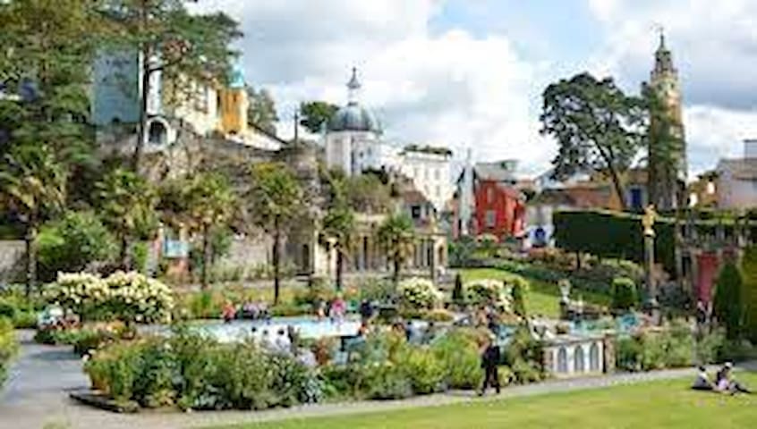
Portmeirion
Postcode district: LL48
OS grid reference: SH588370
Post town: PENRHYNDEUDRAETH
Italian village and gardens, set next to the Dwyryd Estuary on the coast.
Open all year round from 9.30am to 7pm for day visits with reduced entry after 3.30pm.
The village has 6 restaurants and cafes, 6 shops, a spa, an information centre, an audio visual presentation and a resident artist's gallery.
Free guided tours are available from the information centre near the entrance, during our peak season.
We are Closed to the public for Christmas Day.
Beddgelert, Caernarfon LL55 4NE
Sygun Copper Mine is a Victorian copper mine which closed in 1903 but was renovated and reopened by the Amies family as a tourist attraction in 1986, focusing on audio-visual tours of the underground workings.
27 íbúar mæla með
Sygun Copper Mine
Beddgelert, Caernarfon LL55 4NE
Sygun Copper Mine is a Victorian copper mine which closed in 1903 but was renovated and reopened by the Amies family as a tourist attraction in 1986, focusing on audio-visual tours of the underground workings.
55 min (35.8 mi)
via A470 from cabins
Bodnant Garden
A world-famous garden home to National Collections and Champion Trees
Tal-y-Cafn, near Colwyn Bay, Conwy, LL28 5RE
194 íbúar mæla með
National Trust - Bodnant Garden
Bodnant Road55 min (35.8 mi)
via A470 from cabins
Bodnant Garden
A world-famous garden home to National Collections and Champion Trees
Tal-y-Cafn, near Colwyn Bay, Conwy, LL28 5RE
Activities
Fantastic fun.#
A 25 Min drive from cabins
Address:
National White Water Centre
Frongoch
Bala
Gwynedd
LL23 7NU
72 íbúar mæla með
Þjóðarhvíta Vatn Miðstöð - Canolfan Dŵr Gwyn Genedlaethol
Fantastic fun.#
A 25 Min drive from cabins
Address:
National White Water Centre
Frongoch
Bala
Gwynedd
LL23 7NU
Offer a range of activities:
High ropes or low ropes
Climbing Walls
Leap of faith
Abseiling
Climbing
Coaststeering
Caving
Hill walking or scrambling
Water sport
Bush crafts/ Foraging/
Orienteering/ scavenger hunts
Address:
Gilfach Ddu, Padarn Country Park, Llanberis, Gwynedd, LL55 4TY
Ropeworks Active Limited
Offer a range of activities:
High ropes or low ropes
Climbing Walls
Leap of faith
Abseiling
Climbing
Coaststeering
Caving
Hill walking or scrambling
Water sport
Bush crafts/ Foraging/
Orienteering/ scavenger hunts
Address:
Gilfach Ddu, Padarn Country Park, Llanberis, Gwynedd, LL55 4TY
Outdoor adventures individually tailored.
offering:
Coasteering
Rock climbing
kayaking
Canyoning
and many more activities.
Adrenalin Addicts
31 Cae GwastadOutdoor adventures individually tailored.
offering:
Coasteering
Rock climbing
kayaking
Canyoning
and many more activities.
Trawsfynydd Lake offers families and individuals many activities such as fishing, walking, cycling and many more.
A stunning circular trail of 8 miles around the lake, hybrid or mountain bikes are highly recommended if cycling.
BIKE HIRE available at the visitors centre near the cafe.
Address: Trawsfynydd, Blaenau Ffestiniog LL41 4SH
Trawsfynydd Lake Car Park
Trawsfynydd Lake offers families and individuals many activities such as fishing, walking, cycling and many more.
A stunning circular trail of 8 miles around the lake, hybrid or mountain bikes are highly recommended if cycling.
BIKE HIRE available at the visitors centre near the cafe.
Address: Trawsfynydd, Blaenau Ffestiniog LL41 4SH
Ultimate Sleddog |Experience.
Mynydd Sleddog Adventures is Wales' first and only outdoor activity provider, specialising in husky rides and sleddog adventures with our team of racing sled ...
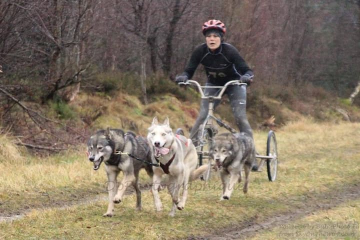
Mynydd Sleddog Adventures
Ultimate Sleddog |Experience.
Mynydd Sleddog Adventures is Wales' first and only outdoor activity provider, specialising in husky rides and sleddog adventures with our team of racing sled ...
Address: Cibyn Industrial Estate, Caernarfon LL55 2BD
The biggest and best indoor climbing around.
Year-round all weather venue open every day.
Climbing for all ages from 2 to 90+.
Complete beginner to advanced level.
Expert tuition for all levels including groups.
Café with birthday party & group catering.
Plenty of free car parking.
Free WiFi.
We are open 7 days a week:
Visiting with friends or family but not climbing, or just fancy having a look around? Spectators are free to relax in the seating areas and café overlooking the climbing walls.
37 íbúar mæla með
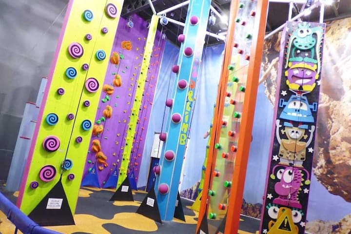
Beacon Climbing Centre
Address: Cibyn Industrial Estate, Caernarfon LL55 2BD
The biggest and best indoor climbing around.
Year-round all weather venue open every day.
Climbing for all ages from 2 to 90+.
Complete beginner to advanced level.
Expert tuition for all levels including groups.
Café with birthday party & group catering.
Plenty of free car parking.
Free WiFi.
We are open 7 days a week:
Visiting with friends or family but not climbing, or just fancy having a look around? Spectators are free to relax in the seating areas and café overlooking the climbing walls.
Paintball Wales, Warrior Woods Llanddeiniolen, Gwynedd, Snowdonia, North LL55 3AX
An AMAZING day out for friends & Family
Fun – Excitement – Adrenaline – Adventure
Paintball Wales - North Wales, Snowdonia
Paintball Wales, Warrior Woods Llanddeiniolen, Gwynedd, Snowdonia, North LL55 3AX
An AMAZING day out for friends & Family
Fun – Excitement – Adrenaline – Adventure
We are based in Betws Y Coed, North Wales and offer private Bespoke & mixed adventure activities every day.
North Wales Active has now been going for over 15 years. We have a range of activities and prices advertised. If you have anything else in mind please dont hesitate to ask.
North Wales Active offers a range of adventure activies all year round including coasteering, gorge walking, canyoning, climbing, abseiling and mountain walking.
North Wales Active
Holyhead RoadWe are based in Betws Y Coed, North Wales and offer private Bespoke & mixed adventure activities every day.
North Wales Active has now been going for over 15 years. We have a range of activities and prices advertised. If you have anything else in mind please dont hesitate to ask.
North Wales Active offers a range of adventure activies all year round including coasteering, gorge walking, canyoning, climbing, abseiling and mountain walking.
Unit 2, Y Glyn, Llanberis, Caernarfon LL55 4EL
Kit Hire
Single Seat Kayaks - (includes a paddle, a buoyancy aid and a wetsuit) - £25.00 per kayak for 2 hours
Paddleboard - (includes a buoyancy aid and a wetsuit) - £25.00 per paddle board for 2 hours
Tandem Kayaks - (includes 2 paddles, 2 buoyancy aids and 2 wetsuits) - £35.00 per tandem kayak for 2 hours
XL Paddleboard - (includes up to 6 paddles, up to 6 buoyancy aids and up to 6 wet-suits) - £60.00 per XL paddleboard for 2 hours
Please note we do not rent open canoes or rowing boats.
Please consider the following points before you book any equipment.
Kayaking and paddleboarding can be physically demanding.
There are no safety patrols, life guards or instructors supervising rental customers.
Kit hire sessions are not instructor lead lessons.
23 íbúar mæla með
Snowdonia Watersports
Unit 2, Y Glyn, Llanberis, Caernarfon LL55 4EL
Kit Hire
Single Seat Kayaks - (includes a paddle, a buoyancy aid and a wetsuit) - £25.00 per kayak for 2 hours
Paddleboard - (includes a buoyancy aid and a wetsuit) - £25.00 per paddle board for 2 hours
Tandem Kayaks - (includes 2 paddles, 2 buoyancy aids and 2 wetsuits) - £35.00 per tandem kayak for 2 hours
XL Paddleboard - (includes up to 6 paddles, up to 6 buoyancy aids and up to 6 wet-suits) - £60.00 per XL paddleboard for 2 hours
Please note we do not rent open canoes or rowing boats.
Please consider the following points before you book any equipment.
Kayaking and paddleboarding can be physically demanding.
There are no safety patrols, life guards or instructors supervising rental customers.
Kit hire sessions are not instructor lead lessons.
Glasfryn Parc, Y ffor, Ll53 6PG
39 min (24.3 mi) from cabins
via A487 and A497
Fun filled family day out North Wales. There's something for everyone from GoKarting, Wakeboarding, Ten Pin Bowling and more...
67 íbúar mæla með
Glasfryn Parc
Glasfryn Parc, Y ffor, Ll53 6PG
39 min (24.3 mi) from cabins
via A487 and A497
Fun filled family day out North Wales. There's something for everyone from GoKarting, Wakeboarding, Ten Pin Bowling and more...
Zip World Penrhyn
1 hr 1 min (38.8 mi)
via A470 and A5
Penrhyn Slate Quarry, located near Bethesda in North Wales, is home to Zip World Velocity 2, the fastest zip line in the world and the longest in Europe.
Experience the Penrhyn Quarry Tour on one of our famous red trucks, or take on Velocity 2 itself!
475 íbúar mæla með
Zip World Penrhyn Quarry
Zip World Penrhyn
1 hr 1 min (38.8 mi)
via A470 and A5
Penrhyn Slate Quarry, located near Bethesda in North Wales, is home to Zip World Velocity 2, the fastest zip line in the world and the longest in Europe.
Experience the Penrhyn Quarry Tour on one of our famous red trucks, or take on Velocity 2 itself!
Distance from Cabins: 34min (21.9 mi)
via A470 and B4407
Zip World Fforest is a woodland setting. With adventures to keep the whole family busy all day, choose from the
Fforest Coaster, the UK’s only alpine coaster of its kind,
bouncing fun on Treetop Nets
zip line and adventure courses high in the trees on Tree Hoppers,
Zip Safari
– plus you could try Europe’s highest giant swing, Skyride, if you dare!
312 íbúar mæla með
Zip World Fforest
A470Distance from Cabins: 34min (21.9 mi)
via A470 and B4407
Zip World Fforest is a woodland setting. With adventures to keep the whole family busy all day, choose from the
Fforest Coaster, the UK’s only alpine coaster of its kind,
bouncing fun on Treetop Nets
zip line and adventure courses high in the trees on Tree Hoppers,
Zip Safari
– plus you could try Europe’s highest giant swing, Skyride, if you dare!
Distance from Cabins: 23 min (13.8 mi)
via A470 and B4410.
Visitors can watch fish deliveries to the nest, chicks feeding on screen and see ospreys soaring high above the valley. Knowledgeable volunteers explain the story of Glaslyn’s ospreys in a friendly environment.
12 íbúar mæla með
Bywyd Gwyllt Glaslyn Wildlife - Ospreys
Distance from Cabins: 23 min (13.8 mi)
via A470 and B4410.
Visitors can watch fish deliveries to the nest, chicks feeding on screen and see ospreys soaring high above the valley. Knowledgeable volunteers explain the story of Glaslyn’s ospreys in a friendly environment.
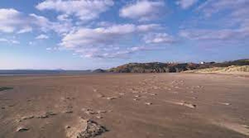
Beaches
28 min (18.9 mi)
via A470 and A496
Barmouth is southern Snowdonia’s most popular seaside resort, its big sandy beach it has miles of unbroken sands that it never gets overcrowded. There’s a picturesque harbour too, perched on the mouth of the beautiful Mawddach Estuary – fishing, sea and estuary trips depart from here. Barmouth is well located for watersports – there’s easy access to the sea via a slipway on the beach, though a craft exclusion zone is in place to protect swimmers, and there are also restrictions on dogs. As a fully fledged seaside resort Barmouth comes complete with all the expected amenities and attractions – shops, cafés and restaurants, good parking, amusements and entertainments. There’s good disabled access to the beach too, and the resort is well served by public transport.
Barmouth beach
28 min (18.9 mi)
via A470 and A496
Barmouth is southern Snowdonia’s most popular seaside resort, its big sandy beach it has miles of unbroken sands that it never gets overcrowded. There’s a picturesque harbour too, perched on the mouth of the beautiful Mawddach Estuary – fishing, sea and estuary trips depart from here. Barmouth is well located for watersports – there’s easy access to the sea via a slipway on the beach, though a craft exclusion zone is in place to protect swimmers, and there are also restrictions on dogs. As a fully fledged seaside resort Barmouth comes complete with all the expected amenities and attractions – shops, cafés and restaurants, good parking, amusements and entertainments. There’s good disabled access to the beach too, and the resort is well served by public transport.
31 min (15.0 mi)
via A496
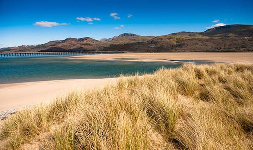
Harlech Beach LL46 2UB
Harlech Beach provides a four-mile stretch of pristine golden sand, with stunning views of the Snowdonia mountain range. The beach is backed by grassy dunes.
A pay and display is in operation at the car park next to the beach entrance.
56 íbúar mæla með
Harlech Beach
31 min (15.0 mi)
via A496
Harlech Beach LL46 2UB
Harlech Beach provides a four-mile stretch of pristine golden sand, with stunning views of the Snowdonia mountain range. The beach is backed by grassy dunes.
A pay and display is in operation at the car park next to the beach entrance.
25 min (14.7 mi)
via A487
Black Rock Sands is an open, wide beach with fine sands. The name comes from the area to the west of the beach dominated by a large, multi-coloured headland rock, low-tide caves and rock pools, an area rich in marine life. Natural history is also a feature of the local sand dunes, which have been declared a ‘Site of Special Scientific Interest’. Unusually, you can drive onto the beach here (there is a fee of around £5 a car)– so it’s a popular spot not just for picnickers and sandcastle builders, but also for motor boats and water bikes which have a special zone designated for their use. There are also dog restrictions zones.
18 íbúar mæla með
Morfa Bychan
25 min (14.7 mi)
via A487
Black Rock Sands is an open, wide beach with fine sands. The name comes from the area to the west of the beach dominated by a large, multi-coloured headland rock, low-tide caves and rock pools, an area rich in marine life. Natural history is also a feature of the local sand dunes, which have been declared a ‘Site of Special Scientific Interest’. Unusually, you can drive onto the beach here (there is a fee of around £5 a car)– so it’s a popular spot not just for picnickers and sandcastle builders, but also for motor boats and water bikes which have a special zone designated for their use. There are also dog restrictions zones.
39 min (20.1 mi)
via A496
About Shell Island
Shells are found in abundance after the winter storms and high tides.
More than 200 different varieties of shells can be found over a season. Some are so small, a magnifying glass is a necessary piece of equipment!.
Wild Flowers - Wild Flowers are found in great numbers, 13 species of wild orchid have been seen over a season. Photograph by all means but please don't pick.
Fishing - Rock-pools keep the children happy for hours looking for prawns, crabs, winkles etc. Lobsters and large edible crabs can be caught by net and hook. If you are after Bass, Plaice, Flounder, Dogfish etc. bring your rod! Bait can be collected locally.
Bathing Beaches - Shell Island has three fine sandy bathing beaches. The main bathing beach which extends for several miles is overlooked by a car park and backed by sandunes
Birds - Wild Birds are found in great numbers on Shell Island. The Estuary is a haven for all kinds of wildlife. Seasonal influxes of migrating birds jostle in the streams within calling distance of the island. A family of swans regularly grace the estuary during the summer
with their young.
Views - The panoramic scenery on a fine day from Shell Island, is second to none, with views of the Lleyn Peninsular, the Snowdon Range, Harlech Castle, The Rhinogs, the foothills of Cader Idris, and the coastline extending down to Pembrokeshire. Relax and enjoy beauty at its best.
Boating - Shell Island is a haven for boats of all shapes and sizes and attracts the attentions of young and old alike. The harbour provides an idyllic spot for those who like to relax and watch the coming and goings of boats from the waters edge
10 íbúar mæla með
Shell eyja
39 min (20.1 mi)
via A496
About Shell Island
Shells are found in abundance after the winter storms and high tides.
More than 200 different varieties of shells can be found over a season. Some are so small, a magnifying glass is a necessary piece of equipment!.
Wild Flowers - Wild Flowers are found in great numbers, 13 species of wild orchid have been seen over a season. Photograph by all means but please don't pick.
Fishing - Rock-pools keep the children happy for hours looking for prawns, crabs, winkles etc. Lobsters and large edible crabs can be caught by net and hook. If you are after Bass, Plaice, Flounder, Dogfish etc. bring your rod! Bait can be collected locally.
Bathing Beaches - Shell Island has three fine sandy bathing beaches. The main bathing beach which extends for several miles is overlooked by a car park and backed by sandunes
Birds - Wild Birds are found in great numbers on Shell Island. The Estuary is a haven for all kinds of wildlife. Seasonal influxes of migrating birds jostle in the streams within calling distance of the island. A family of swans regularly grace the estuary during the summer
with their young.
Views - The panoramic scenery on a fine day from Shell Island, is second to none, with views of the Lleyn Peninsular, the Snowdon Range, Harlech Castle, The Rhinogs, the foothills of Cader Idris, and the coastline extending down to Pembrokeshire. Relax and enjoy beauty at its best.
Boating - Shell Island is a haven for boats of all shapes and sizes and attracts the attentions of young and old alike. The harbour provides an idyllic spot for those who like to relax and watch the coming and goings of boats from the waters edge
Biking & Walks
Address: Coed Y Brenin Visitor Centre Dolgefeiliau, Ganllwyd, Dolgellau LL40 2HZ
World-class mountain bike trails
Coed y Brenin was the first purpose-built mountain bike centre in the UK and it is still the largest. It is home to eight mountain bike trails, a skills area and a bike hire and retail shop. All of the mountain biking trails are waymarked and start from the visitor centre car park. From retro, rocky, classics to modern contemporary trails, there are rides to satisfy first timers to seasoned pros! The black graded ‘Beast’ is the one experienced riders aspire to, while the blue graded ‘Minotaur’, the most popular trail in Coed y Brenin, is ideal for all ages as well as adaptive bikes. The 5 mile ‘Yr Afon’ forest road trail is great for families and those who prefer a more leisurely pace, and takes in some of the most picturesque scenery in Coed y Brenin.
62 íbúar mæla með
Coed-y-Brenin
Address: Coed Y Brenin Visitor Centre Dolgefeiliau, Ganllwyd, Dolgellau LL40 2HZ
World-class mountain bike trails
Coed y Brenin was the first purpose-built mountain bike centre in the UK and it is still the largest. It is home to eight mountain bike trails, a skills area and a bike hire and retail shop. All of the mountain biking trails are waymarked and start from the visitor centre car park. From retro, rocky, classics to modern contemporary trails, there are rides to satisfy first timers to seasoned pros! The black graded ‘Beast’ is the one experienced riders aspire to, while the blue graded ‘Minotaur’, the most popular trail in Coed y Brenin, is ideal for all ages as well as adaptive bikes. The 5 mile ‘Yr Afon’ forest road trail is great for families and those who prefer a more leisurely pace, and takes in some of the most picturesque scenery in Coed y Brenin.
The Mawddach Trail is a stunning multi-use path following the old disused railway line about 9.5 miles along the edge of the beautiful Mawddach estuary in Southern Snowdonia.
The Mawddach Trail is clearly marked and can be easily followed.
...
There are car parks and entrances to the trail in all of the following locations:
Y Marian, Dolgellau (LL40 1DL)
Pont y Wernddu (LL40 2SR)
Penmaenpool (LL40 1YD)
Arthog (LL39 1AX)
Morfa Mawddach (LL39 1BQ)
Barmouth (LL42 1LX)
52 íbúar mæla með
The Mawddach Trail
The Mawddach Trail is a stunning multi-use path following the old disused railway line about 9.5 miles along the edge of the beautiful Mawddach estuary in Southern Snowdonia.
The Mawddach Trail is clearly marked and can be easily followed.
...
There are car parks and entrances to the trail in all of the following locations:
Y Marian, Dolgellau (LL40 1DL)
Pont y Wernddu (LL40 2SR)
Penmaenpool (LL40 1YD)
Arthog (LL39 1AX)
Morfa Mawddach (LL39 1BQ)
Barmouth (LL42 1LX)
Bala Lake (or Llyn Tegid) is the largest natural lake in Wales. The area on the south side of the lake is wonderful for walkers. Footpaths climb into the hills and forests for fabulous views of the lake below.
The walk begins in Bala, at the visitor centre on the foreshore of the lake. You then follow footpaths along the lakeside before ascending to Craigy-Allor. From here the views over the lake and surrounding mountains are splendid. The route then descends through forest and countryside to Llanuwchllyn station. From here you can catch the Bala Lake railway back to Bala. The narrow gauge steam train runs along the southern end of the lake. It's a lovely journey with fine views of the lake and Arenig Fawr, Aran Benllyn and Aran Fawddw mountains.
To continue your walking in the area you could climb Aran Fawddwy.
The walk starts from the village of Llanuwchllyn near the southern end of the lake.
You could also head to the nearby Llyn Celyn where there's more lovely scenery and walks to try.
87 íbúar mæla með
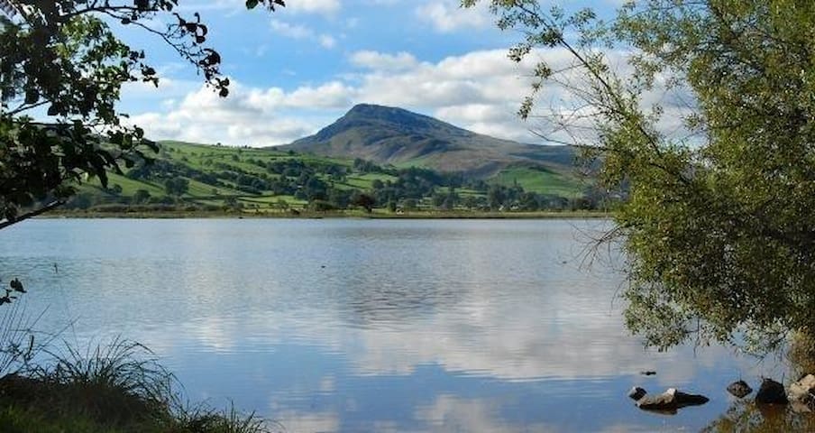
Llyn Tegid
Bala Lake (or Llyn Tegid) is the largest natural lake in Wales. The area on the south side of the lake is wonderful for walkers. Footpaths climb into the hills and forests for fabulous views of the lake below.
The walk begins in Bala, at the visitor centre on the foreshore of the lake. You then follow footpaths along the lakeside before ascending to Craigy-Allor. From here the views over the lake and surrounding mountains are splendid. The route then descends through forest and countryside to Llanuwchllyn station. From here you can catch the Bala Lake railway back to Bala. The narrow gauge steam train runs along the southern end of the lake. It's a lovely journey with fine views of the lake and Arenig Fawr, Aran Benllyn and Aran Fawddw mountains.
To continue your walking in the area you could climb Aran Fawddwy.
The walk starts from the village of Llanuwchllyn near the southern end of the lake.
You could also head to the nearby Llyn Celyn where there's more lovely scenery and walks to try.
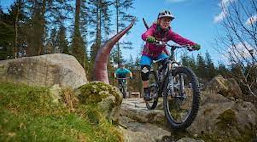
Big mountain trails in Blaenau Ffestiniog
They’ve certainly been busy in the former ‘slate capital’ of Blaenau Ffestiniog, where off-road cycling enthusiasts are already raving about the award winning Antur Stiniog mountain biking centre in an old slate quarry. The super-fast flowing trails have rollers, jumps, drops and rock features as well as some of the best berms around
37 íbúar mæla með
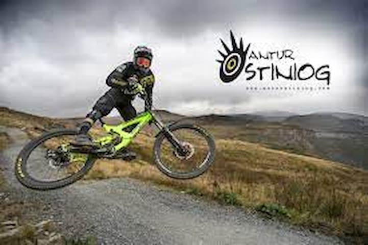
Antur Stiniog
Big mountain trails in Blaenau Ffestiniog
They’ve certainly been busy in the former ‘slate capital’ of Blaenau Ffestiniog, where off-road cycling enthusiasts are already raving about the award winning Antur Stiniog mountain biking centre in an old slate quarry. The super-fast flowing trails have rollers, jumps, drops and rock features as well as some of the best berms around
Walks
Parking – Free
Toilet facilities – Yes
Length – 5km
Duration – approximately 2 hours
Highlights – Stunning Views of the Mawddach Estuary with views of Abermaw (Barmouth) Bridge
Ascent: Some rough, wet terrain. Wear appropriate footwear
Time: Around 2 hours
Grade: Moderate Walk
Start/Finish: National Park car park at Saith Groesffordd, Llanfachreth (SH 746 212)
Parking: SNPA car park (free parking, toilets).
Post Code: LL40 2NG
Relevant Map: OS Ordnans Exp OL18 (Harlech, Porthmadog and Bala)
New Precipice Walk offers superb views from the Arran Mountains to the East, to Barmouth and beyond to the west and all the while you gaze down on the meandering Mawddach Estuary with a beautiful view of Penmaenpool and it's wooden toll bridge.
6 íbúar mæla með
New Precipice Walk
Parking – Free
Toilet facilities – Yes
Length – 5km
Duration – approximately 2 hours
Highlights – Stunning Views of the Mawddach Estuary with views of Abermaw (Barmouth) Bridge
Ascent: Some rough, wet terrain. Wear appropriate footwear
Time: Around 2 hours
Grade: Moderate Walk
Start/Finish: National Park car park at Saith Groesffordd, Llanfachreth (SH 746 212)
Parking: SNPA car park (free parking, toilets).
Post Code: LL40 2NG
Relevant Map: OS Ordnans Exp OL18 (Harlech, Porthmadog and Bala)
New Precipice Walk offers superb views from the Arran Mountains to the East, to Barmouth and beyond to the west and all the while you gaze down on the meandering Mawddach Estuary with a beautiful view of Penmaenpool and it's wooden toll bridge.
Distance: 6.0 km / 4 miles
Approx time: 2 hours
Ascent: Woodland paths and minor roads/tracks.
Wear appropriate waterproof footwear.
Time: Around 2 hours
Grade: Moderate Walk
Start/Finish: Penmaenpool car park, near Dolgellau (SH 696 185) Penmaenpool car park, near Dolgellau (SH 696 185)
Parking:
Post Code: LL40 1YE
Relevant Map: OS Ordnans Exp OL23 (Cader Idris & Llyn Tegid)
Ordnance Survey Map: OS Explorer OL18 Harlech, Porthmadog and Bala
Abergwynant Woods is a 90-acre woodland situated between Dolgellau and Barmouth. The Mawddach Estuary, which leads towards Barmouth, runs alongside the woodland. The route also follows part of the Mawddach Trail, a 15km trail between Dolgellau and Barmouth.
The Gwynant river, which originates at the foot of nearby Cader Idris, meanders through the forest floor, allowing species such as mosses and lichens to grow in abundance. Abergwynant is also home to many woodland species such as fungi, frogs and newts. Native trees including oak, birch and holly also grow here.
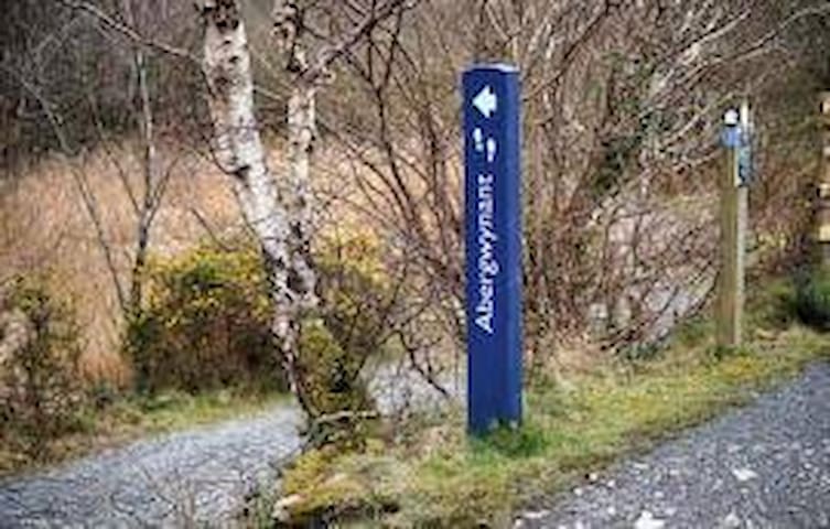
Abergwynant Woods
Distance: 6.0 km / 4 miles
Approx time: 2 hours
Ascent: Woodland paths and minor roads/tracks.
Wear appropriate waterproof footwear.
Time: Around 2 hours
Grade: Moderate Walk
Start/Finish: Penmaenpool car park, near Dolgellau (SH 696 185) Penmaenpool car park, near Dolgellau (SH 696 185)
Parking:
Post Code: LL40 1YE
Relevant Map: OS Ordnans Exp OL23 (Cader Idris & Llyn Tegid)
Ordnance Survey Map: OS Explorer OL18 Harlech, Porthmadog and Bala
Abergwynant Woods is a 90-acre woodland situated between Dolgellau and Barmouth. The Mawddach Estuary, which leads towards Barmouth, runs alongside the woodland. The route also follows part of the Mawddach Trail, a 15km trail between Dolgellau and Barmouth.
The Gwynant river, which originates at the foot of nearby Cader Idris, meanders through the forest floor, allowing species such as mosses and lichens to grow in abundance. Abergwynant is also home to many woodland species such as fungi, frogs and newts. Native trees including oak, birch and holly also grow here.
Highly recommended far nicer than Snowdon!!
Minffordd Path
10km / 6 miles, allow 5 hours there and back
Pony Path
10km / 6 miles, allow 5 hours there and back
Llanfihangel y Pennant Path
16km / 10miles, allow 7 hours there and back
You can park your car at Dôl Idris Tywyn LL36 9AJ(Minffordd), Llanfihangel y Pennant and Tŷ Nant Dolgellau (LL40 1). The Dôl Idris and Tŷ Nant car parks are run by Snowdonia National Park and there is a charge to use them – take the right money as they don’t give change. Find out the up to date information on the Snowdonia National Park car parks page. It’s best to get there early as they can fill up at busy times. The Llanfihangel y Pennant village car park is free to use but it’s quite small.
There are toilets at each of the car parks which is useful as there aren’t any on the mountain.
Pony Path
10km / 6 miles, allow 5 hours there and back
The Pony Path starts from the Dolgellau side of Cader. It’s probably the most popular route, heading up the mountainside to the curve of the cliff edge above Llyn y Gader. Starting from Tŷ Nant car park, it's a steepish climb with steps in several places to help you along. On the way you’ll see spectacular views over the Mawddach estuary towards Barmouth. Once you get to the ridge over Llyn y Gader you'll get fab views inland towards Bala and over the lake. Follow the steep path to Penygadair. Then it's a scramble up to the trig point.
Minffordd Path
10km / 6 miles, allow 5 hours there and back
The shortest route but the steepest. The Minffordd Path starts near the Visitor Centre and café. To start with, you’ll climb up lots and lots of steps, before walking along the ridge above Llyn Cau toward Penygadair. Take care coming back down from the summit, as it’s easy to miss the path and you probably don’t want to end up walking towards Dolgellau.
The seasonal Visitor Centre is worth a visit as there’s plenty of information about Cader. There are also short walks around the nature reserve, including accessible broadwalks, to explore the lower lakes and waterfalls.
Llanfihangel y Pennant Path
16km / 10miles, allow 7 hours there and back
If you’re after peace and quiet, the longer Llanfihangel-y-Pennant Path is usually the perfect route to take. Llanfihangel y Pennant is a hamlet deep in the remote Dysynni Valley and an interesting place to visit in its own right. It’s reached by a narrow single track road, passing the romantic ruins of Castell y Bere on the way. The small car park and toilets are opposite St. Michael’s Church.
The path is well marked and there are several places you can rest and appreciate the unfolding views of the Dysynni Valley down towards the coast or across to the summit of Tarrenhendre. Compared to the other paths, it’s fairly gentle until you join the Pony Path, then it’s a hard plod up to Penygadair.
66 íbúar mæla með
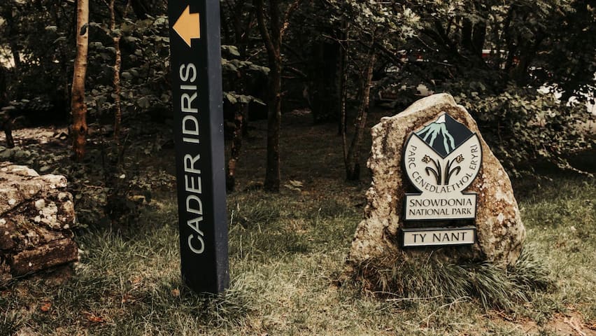
Cadair Idris - Penygadair
Highly recommended far nicer than Snowdon!!
Minffordd Path
10km / 6 miles, allow 5 hours there and back
Pony Path
10km / 6 miles, allow 5 hours there and back
Llanfihangel y Pennant Path
16km / 10miles, allow 7 hours there and back
You can park your car at Dôl Idris Tywyn LL36 9AJ(Minffordd), Llanfihangel y Pennant and Tŷ Nant Dolgellau (LL40 1). The Dôl Idris and Tŷ Nant car parks are run by Snowdonia National Park and there is a charge to use them – take the right money as they don’t give change. Find out the up to date information on the Snowdonia National Park car parks page. It’s best to get there early as they can fill up at busy times. The Llanfihangel y Pennant village car park is free to use but it’s quite small.
There are toilets at each of the car parks which is useful as there aren’t any on the mountain.
Pony Path
10km / 6 miles, allow 5 hours there and back
The Pony Path starts from the Dolgellau side of Cader. It’s probably the most popular route, heading up the mountainside to the curve of the cliff edge above Llyn y Gader. Starting from Tŷ Nant car park, it's a steepish climb with steps in several places to help you along. On the way you’ll see spectacular views over the Mawddach estuary towards Barmouth. Once you get to the ridge over Llyn y Gader you'll get fab views inland towards Bala and over the lake. Follow the steep path to Penygadair. Then it's a scramble up to the trig point.
Minffordd Path
10km / 6 miles, allow 5 hours there and back
The shortest route but the steepest. The Minffordd Path starts near the Visitor Centre and café. To start with, you’ll climb up lots and lots of steps, before walking along the ridge above Llyn Cau toward Penygadair. Take care coming back down from the summit, as it’s easy to miss the path and you probably don’t want to end up walking towards Dolgellau.
The seasonal Visitor Centre is worth a visit as there’s plenty of information about Cader. There are also short walks around the nature reserve, including accessible broadwalks, to explore the lower lakes and waterfalls.
Llanfihangel y Pennant Path
16km / 10miles, allow 7 hours there and back
If you’re after peace and quiet, the longer Llanfihangel-y-Pennant Path is usually the perfect route to take. Llanfihangel y Pennant is a hamlet deep in the remote Dysynni Valley and an interesting place to visit in its own right. It’s reached by a narrow single track road, passing the romantic ruins of Castell y Bere on the way. The small car park and toilets are opposite St. Michael’s Church.
The path is well marked and there are several places you can rest and appreciate the unfolding views of the Dysynni Valley down towards the coast or across to the summit of Tarrenhendre. Compared to the other paths, it’s fairly gentle until you join the Pony Path, then it’s a hard plod up to Penygadair.
Distance 9.82 km/Ascent 582 m/Time 5 hours
Very complex terrain with some sections of easy scrambling.
Rhinog Fawr is a mountain in Snowdonia, North Wales and forms part of the Rhinogydd range. It is the third highest summit of the Rhinogydd, shorter only to Y Llethr and Diffwys respectively. Its smaller cousin Rhinog Fach is located in the south, separated by the pass of Bwlch Drws Ardudwy, while Moel Ysgyfarnogod is in the north. The terrain in this area is characterised by hard sedimentary rock covered with heather, so allow for extra time as this does make footing a bit more tricky.
Take in the breathtaking views and the tranquil waters. Nature never fails. Enjoy.
Route Start Location: Graigddu-isaf Car Park - SH 683 301
Distance 9.82 km
Ascent 582 m
Time 5 hours
9 íbúar mæla með
Rhinog Fawr
Distance 9.82 km/Ascent 582 m/Time 5 hours
Very complex terrain with some sections of easy scrambling.
Rhinog Fawr is a mountain in Snowdonia, North Wales and forms part of the Rhinogydd range. It is the third highest summit of the Rhinogydd, shorter only to Y Llethr and Diffwys respectively. Its smaller cousin Rhinog Fach is located in the south, separated by the pass of Bwlch Drws Ardudwy, while Moel Ysgyfarnogod is in the north. The terrain in this area is characterised by hard sedimentary rock covered with heather, so allow for extra time as this does make footing a bit more tricky.
Take in the breathtaking views and the tranquil waters. Nature never fails. Enjoy.
Route Start Location: Graigddu-isaf Car Park - SH 683 301
Distance 9.82 km
Ascent 582 m
Time 5 hours
Route details
National Trust car park, Nantmor, grid ref: SH597462.
DifficultyChallenging
Time4 hours - 5 hours
Distance5.7 miles (9.1 km)
MapLeisure 17; Landranger 115
Dogs allowedDog friendly
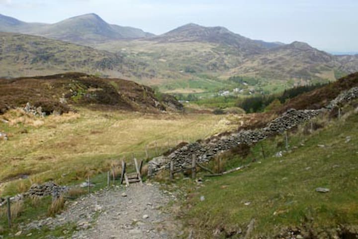
Aberglaslyn, Llyn Dinas and Cwm Bychan walk
Along this route you'll take in the spectacular Aberglaslyn gorge with the Glaslyn river raging alongside the path, Bedd y Ci (the grave of Prince Llywelyn's faithful hound), the beautiful village of Beddgelert, the placid waters of Llyn Dinas and the old copper mine workings of Sygun and Cwm Bychan.
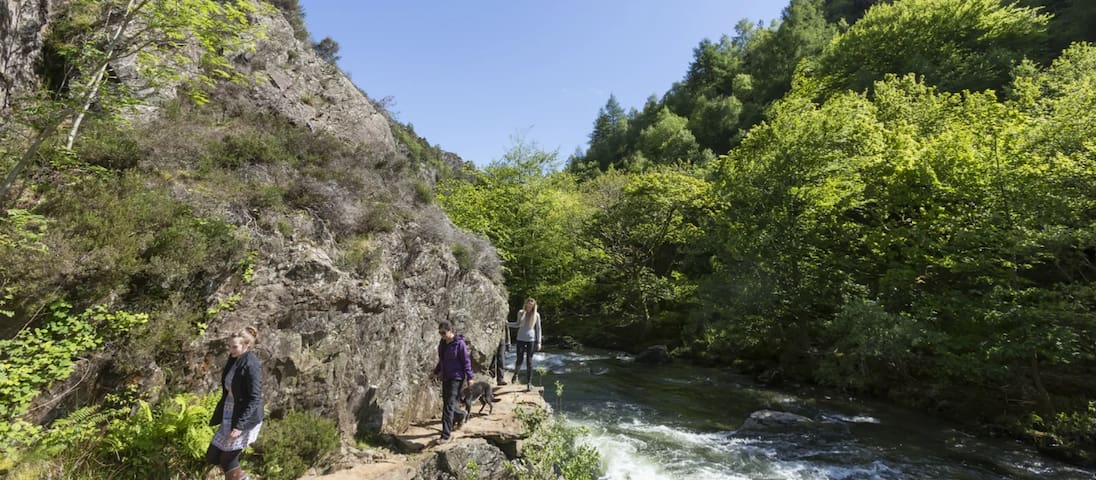
Aberglaslyn Pass
Route details
National Trust car park, Nantmor, grid ref: SH597462.
DifficultyChallenging
Time4 hours - 5 hours
Distance5.7 miles (9.1 km)
MapLeisure 17; Landranger 115
Dogs allowedDog friendly
Aberglaslyn, Llyn Dinas and Cwm Bychan walk
Along this route you'll take in the spectacular Aberglaslyn gorge with the Glaslyn river raging alongside the path, Bedd y Ci (the grave of Prince Llywelyn's faithful hound), the beautiful village of Beddgelert, the placid waters of Llyn Dinas and the old copper mine workings of Sygun and Cwm Bychan.
The walk is short - about 1-mile round trip - and well signposted. The going is fairly easy and should pose no problems for anyone of reasonable mobility.
Dog friendly though be we did see stray sheep on the track.
The walk begins at the Dolgoch Falls Hotel on the B4405, easily reached from Tywyn or Machynlleth. Parking is free but there is a donation box
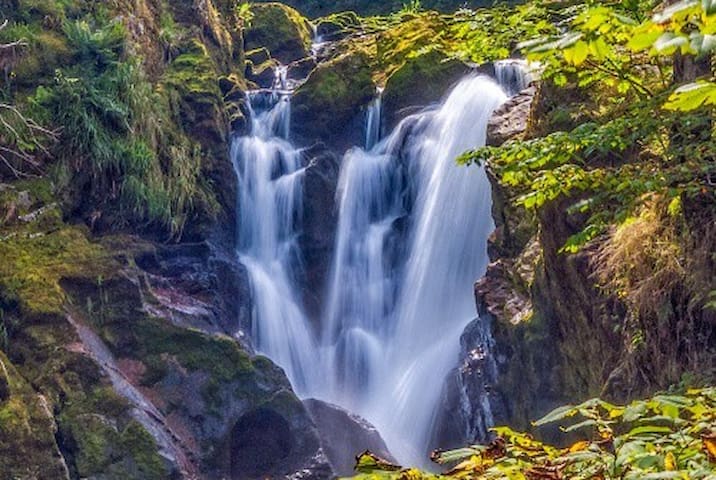
It’s not every day you see a gorgeous backdrop of cascading waterfalls, and yet The Dolgoch Falls consist of three! With striking views and a series of caves and tunnels to explore, Dolgoch Falls is the ideal walking spot with beautiful scenery.
23 íbúar mæla með
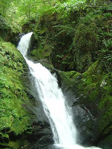
Dolgoch Falls
The walk is short - about 1-mile round trip - and well signposted. The going is fairly easy and should pose no problems for anyone of reasonable mobility.
Dog friendly though be we did see stray sheep on the track.
The walk begins at the Dolgoch Falls Hotel on the B4405, easily reached from Tywyn or Machynlleth. Parking is free but there is a donation box
It’s not every day you see a gorgeous backdrop of cascading waterfalls, and yet The Dolgoch Falls consist of three! With striking views and a series of caves and tunnels to explore, Dolgoch Falls is the ideal walking spot with beautiful scenery.
It really is a lovely varied 5.6 mile walk, Approx time: 2.5 hours Parking: Padarn Country Park (LL55 4TY) , combining an undulating section of woodland walking on the far side of the Lake, and an easy flat section on the Llanberis side.
Fancy a little adventure? Home to some of the most spectacular views in Snowdonia, this varied and wonderful trail has been a hit with visitors since the Victorian times. With a number of different walks which stretch across various distances, The Panorama Walk is perfect for all; from the more energetic walkers to those looking for a shorter stroll!
Llanberis Lake Llyn Padarn
It really is a lovely varied 5.6 mile walk, Approx time: 2.5 hours Parking: Padarn Country Park (LL55 4TY) , combining an undulating section of woodland walking on the far side of the Lake, and an easy flat section on the Llanberis side.
Fancy a little adventure? Home to some of the most spectacular views in Snowdonia, this varied and wonderful trail has been a hit with visitors since the Victorian times. With a number of different walks which stretch across various distances, The Panorama Walk is perfect for all; from the more energetic walkers to those looking for a shorter stroll!
Coed Felenrhyd & Llennyrch is a rare, Atlantic oak woodland and one of our largest woods in Wales. They are remnants of vast woodlands that once extended from northern Scotland to Portugal. It sits above the Vale of Ffestiniog and is fringed by the dramatic waterfalls of the Afon Prysor gorge in the Snowdonia National Park.
Explore its atmospheric pools and take in dramatic views of Snowdon to the north and the rugged uplands of the Rhinog mountains to the south.
Access
The paths through the wood are narrow, quite steep and have many steps. The 800 metre (1/2 mile) walk to the waterfall is steep in places but well worth the effort. The reserve is not suitable for wheelchair users, prams and pushchairs, or anyone with mobility problems.
Directions from site
Go to the main rd A470 , turn right follow the main road towards Porthmadog.
It is the 2nd Village on the left called GELLILYDAN .
There is an immediate left when you turn into the village ( sign post for Bryn Arms pub)
Go past the pub and stay on the single track. There is a right turn following a high wall on the left. Keep going you will go through 2 gates, 2nd gate is the car park. There is a honesty box to pay for parking £1.50 for the whole day, near the gate.
Once parked, go back through the gate about 200 yards there is a metal gate on the right with a sign pointing the way.
Ceunant Llennyrch National Nature Reserve
Coed Felenrhyd & Llennyrch is a rare, Atlantic oak woodland and one of our largest woods in Wales. They are remnants of vast woodlands that once extended from northern Scotland to Portugal. It sits above the Vale of Ffestiniog and is fringed by the dramatic waterfalls of the Afon Prysor gorge in the Snowdonia National Park.
Explore its atmospheric pools and take in dramatic views of Snowdon to the north and the rugged uplands of the Rhinog mountains to the south.
Access
The paths through the wood are narrow, quite steep and have many steps. The 800 metre (1/2 mile) walk to the waterfall is steep in places but well worth the effort. The reserve is not suitable for wheelchair users, prams and pushchairs, or anyone with mobility problems.
Directions from site
Go to the main rd A470 , turn right follow the main road towards Porthmadog.
It is the 2nd Village on the left called GELLILYDAN .
There is an immediate left when you turn into the village ( sign post for Bryn Arms pub)
Go past the pub and stay on the single track. There is a right turn following a high wall on the left. Keep going you will go through 2 gates, 2nd gate is the car park. There is a honesty box to pay for parking £1.50 for the whole day, near the gate.
Once parked, go back through the gate about 200 yards there is a metal gate on the right with a sign pointing the way.
This secluded and ethereal ancient oakwood was once part of an historic estate and slopes gently down to Llyn Mair (Mary’s Lake). A network of paths allows spectacular views over Snowdonia National Park, while steam trains of the iconic Ffestiniog Railway snake around the boundary.
With rare wildlife and an abundance of stunning flora, Coed Hafod y Llyn is the perfect woodland destination for train buffs and nature lovers alike.
The wood is also part of a network of woodlands around the National Park study centre at Plas Tan y Bwlch. So, if you've still got plenty of energy after you've fully explored Coed Hafod y Llyn, you can keep on going by connecting with the Dyffryn Maentwrog and Llyn Mair footpath network in the Snowdonia National Park, which includes over 30km (18 miles) of paths.
Heading north along the A487 towards Porthmadog, ignore the left turn for Maentwrog and Harlech (A496), and instead continue for a further 0.4km (0.25 miles). Then turn right at the following junction, next to the Oakley Arms and signposted for Rhyd (B4410).
Continue until you can see a lake (Llyn Mair) to the left. Coed Hafod y Llyn is located at the back end of the lake. Enter through the Snowdonia National Park picnic area on the left side, just after the lake.
Coed Hafod-y-llyn
This secluded and ethereal ancient oakwood was once part of an historic estate and slopes gently down to Llyn Mair (Mary’s Lake). A network of paths allows spectacular views over Snowdonia National Park, while steam trains of the iconic Ffestiniog Railway snake around the boundary.
With rare wildlife and an abundance of stunning flora, Coed Hafod y Llyn is the perfect woodland destination for train buffs and nature lovers alike.
The wood is also part of a network of woodlands around the National Park study centre at Plas Tan y Bwlch. So, if you've still got plenty of energy after you've fully explored Coed Hafod y Llyn, you can keep on going by connecting with the Dyffryn Maentwrog and Llyn Mair footpath network in the Snowdonia National Park, which includes over 30km (18 miles) of paths.
Heading north along the A487 towards Porthmadog, ignore the left turn for Maentwrog and Harlech (A496), and instead continue for a further 0.4km (0.25 miles). Then turn right at the following junction, next to the Oakley Arms and signposted for Rhyd (B4410).
Continue until you can see a lake (Llyn Mair) to the left. Coed Hafod y Llyn is located at the back end of the lake. Enter through the Snowdonia National Park picnic area on the left side, just after the lake.
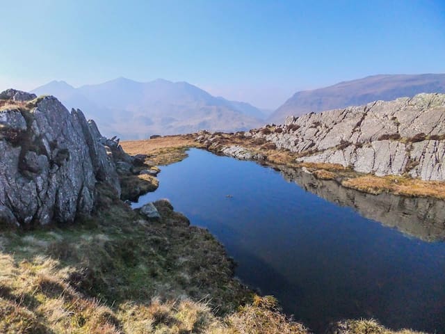
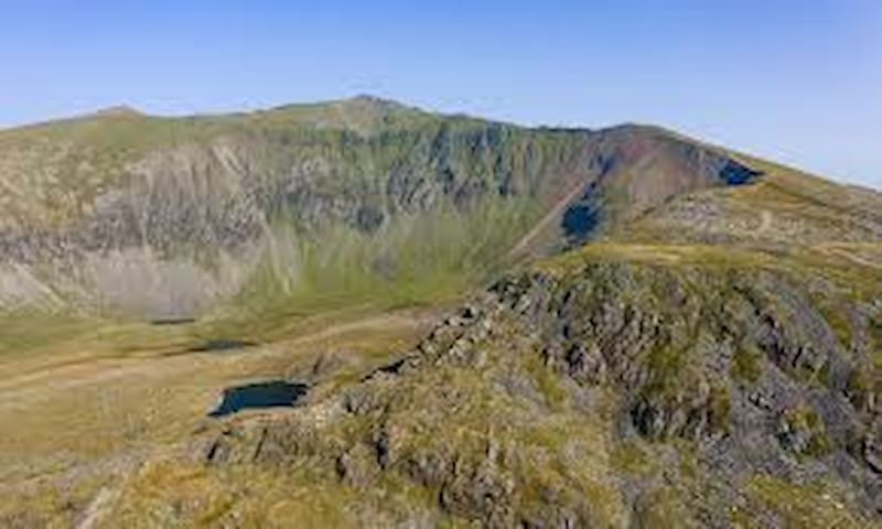
Cwm Idwal is a cirque in the Glyderau range of mountains in northern Snowdonia, the national park in the mountainous region of North Wales. Its main interest is to hill walkers and rock climbers, but it is also of interest to geologists and naturalists, given its combination of altitude, aspect and terrain.
Route details
Ogwen Cottage, Nant Ffrancon, Bethesda, LL57 3LZ (54 minutes from Cabins)
DifficultyModerate
Time3 hours
Distance3 miles (4.8 km)
MapOutdoor Leisure 17; Landranger 115
20 íbúar mæla með
Cwm Idwal
Cwm Idwal is a cirque in the Glyderau range of mountains in northern Snowdonia, the national park in the mountainous region of North Wales. Its main interest is to hill walkers and rock climbers, but it is also of interest to geologists and naturalists, given its combination of altitude, aspect and terrain.
Route details
Ogwen Cottage, Nant Ffrancon, Bethesda, LL57 3LZ (54 minutes from Cabins)
DifficultyModerate
Time3 hours
Distance3 miles (4.8 km)
MapOutdoor Leisure 17; Landranger 115
Machno Falls is a picturesque waterfall on the River Machno (or Afon Machno if you prefer the Welsh) near Betws-y-Coed, Gwynedd. It lies just south (upriver) of the more famous Conwy Falls. There is no easy access from the east side of the river, so getting to the waterfall takes a bit of effort.
GETTING THERE
From the A5 take the B4406 south, past the Conwy Falls cafe, designed by Clough Williams-Ellis, who was responsible for the fantasy village of Portmeirion. You soon come to a road off to the right, leading through Penmachno village and past the derelict remains of the Penmachno Woollen Mill.
Cross the bridge over the Afon Machno, with its views to the 17th-century packhorse bridge known as the Penmachno Roman Bridge on the downstream side.
The narrow country lane turns north, loosely following the west bank of the river for roughly 500m. Past several houses and the remains of the Pandy Mill you will see a lay-by on the right with room for several vehicles. You can catch glimpses of the falls through the trees, depending on the time of year. At the northern end of the lay-by a rough trail leads down to the river for views of the waterfall.
There are no facilities at Machno Falls, but the location is wonderful, and you are unlikely to meet any other visitors.
Roman Bridge, Penmachno
Machno Falls is a picturesque waterfall on the River Machno (or Afon Machno if you prefer the Welsh) near Betws-y-Coed, Gwynedd. It lies just south (upriver) of the more famous Conwy Falls. There is no easy access from the east side of the river, so getting to the waterfall takes a bit of effort.
GETTING THERE
From the A5 take the B4406 south, past the Conwy Falls cafe, designed by Clough Williams-Ellis, who was responsible for the fantasy village of Portmeirion. You soon come to a road off to the right, leading through Penmachno village and past the derelict remains of the Penmachno Woollen Mill.
Cross the bridge over the Afon Machno, with its views to the 17th-century packhorse bridge known as the Penmachno Roman Bridge on the downstream side.
The narrow country lane turns north, loosely following the west bank of the river for roughly 500m. Past several houses and the remains of the Pandy Mill you will see a lay-by on the right with room for several vehicles. You can catch glimpses of the falls through the trees, depending on the time of year. At the northern end of the lay-by a rough trail leads down to the river for views of the waterfall.
There are no facilities at Machno Falls, but the location is wonderful, and you are unlikely to meet any other visitors.
Address: Snowdonia National Park, Swallow Falls, Betws-y-Coed LL24 0DW
Swallow Falls Walk
Grade: Strenuous
Distance: 2¼ miles/3.6 kilometres
Amser: 2½ hours
Trail information: This circular trail is mainly on steep rough narrow paths less than 70 cm wide in some places, on unmade and uneven surfaces, where you can expect mud, rocks and tree roots. There are several flights of steps on the trail and a bench at the waterfall where you can rest and admire the view. There is a wheelchair accessible picnic table in the car park.
From the car park, the path descends through the woodland and the sound of the river gets louder as you approach Swallow Falls and the viewpoint.
The path then winds its way up through trees and rocky outcrops to another viewpoint with views of Moel Siabod, and in clear weather, the Snowdon Horseshoe.
Unlike many of the natural waterfalls around Wales, Swallow Falls does have a small entrance fee to visit. It costs adults £2 to enter, £1 for children and dogs are free of charge. You have to pay your fee before you enter quite a tight full-body turnstile.
49 íbúar mæla með
Swallow Falls Foss
Address: Snowdonia National Park, Swallow Falls, Betws-y-Coed LL24 0DW
Swallow Falls Walk
Grade: Strenuous
Distance: 2¼ miles/3.6 kilometres
Amser: 2½ hours
Trail information: This circular trail is mainly on steep rough narrow paths less than 70 cm wide in some places, on unmade and uneven surfaces, where you can expect mud, rocks and tree roots. There are several flights of steps on the trail and a bench at the waterfall where you can rest and admire the view. There is a wheelchair accessible picnic table in the car park.
From the car park, the path descends through the woodland and the sound of the river gets louder as you approach Swallow Falls and the viewpoint.
The path then winds its way up through trees and rocky outcrops to another viewpoint with views of Moel Siabod, and in clear weather, the Snowdon Horseshoe.
Unlike many of the natural waterfalls around Wales, Swallow Falls does have a small entrance fee to visit. It costs adults £2 to enter, £1 for children and dogs are free of charge. You have to pay your fee before you enter quite a tight full-body turnstile.
Walk up Moel Siabod From Capel Curig
Height Gained – 700 metres, Distance – 5 km, Time –3 hours.
Start Point Details
Ordnance Survey Grid Ref SH735571
Latitude 53.096066 Longitude -3.890643
Postcode LL24 0DT
This is the direct route up to Moel Siabod . It’s a steady plod through the forest, followed by a steady plod up the hill to the summit of Moel Siabod. Despite being regarded as the easier route up Moel Siabod, it can still be difficult to find in descent in mist.
24 íbúar mæla með
Moel Siabod
Walk up Moel Siabod From Capel Curig
Height Gained – 700 metres, Distance – 5 km, Time –3 hours.
Start Point Details
Ordnance Survey Grid Ref SH735571
Latitude 53.096066 Longitude -3.890643
Postcode LL24 0DT
This is the direct route up to Moel Siabod . It’s a steady plod through the forest, followed by a steady plod up the hill to the summit of Moel Siabod. Despite being regarded as the easier route up Moel Siabod, it can still be difficult to find in descent in mist.
Walk up Moel Siabod from Pont Cyfyng
Height Gained – 700 metres, Distance – 4 km, Time –3 hours.
This is a much more interesting walking route than than the tourist path that starts from Plas y Brenin, which is best used as a descent. The NE Ridge is a superior walk along a blunt ridge, skirting the cwm high above Llyn y Foel. Some of the lower reaches can be a bit of a slog. Add around 3km and 50m ascent if you want to start from Capel Curig.
24 íbúar mæla með
Moel Siabod
Walk up Moel Siabod from Pont Cyfyng
Height Gained – 700 metres, Distance – 4 km, Time –3 hours.
This is a much more interesting walking route than than the tourist path that starts from Plas y Brenin, which is best used as a descent. The NE Ridge is a superior walk along a blunt ridge, skirting the cwm high above Llyn y Foel. Some of the lower reaches can be a bit of a slog. Add around 3km and 50m ascent if you want to start from Capel Curig.
Scramble up Moel Siabod via Daear Ddu
Height Gained – 730 metres, Distance – 5 km, Time –3 hours.
This route also starts from Pont Cyfyng, but it’s often walked from Dolwyddelan and it’s by far the best route up. While it may be a scramble, there’s nothing technical about it and is more of a boulder clamber than a scramble. The main danger is navigation as the route isn’t particularly clear (other than keep to the crest and enjoy the scramble!
It also passes through Llyn y Foel, and the cwm into which it nestles. It’s ideally placed for a lunch stop before the main scramble up the Daear Ddu.
Ideally finish the walk by descending to Pont Cyfyng via the NE Ridge rather than the tourist path for the best loop from Capel Curig, or follow the next route for our best Moel Siabod mountain outing.
24 íbúar mæla með
Moel Siabod
Scramble up Moel Siabod via Daear Ddu
Height Gained – 730 metres, Distance – 5 km, Time –3 hours.
This route also starts from Pont Cyfyng, but it’s often walked from Dolwyddelan and it’s by far the best route up. While it may be a scramble, there’s nothing technical about it and is more of a boulder clamber than a scramble. The main danger is navigation as the route isn’t particularly clear (other than keep to the crest and enjoy the scramble!
It also passes through Llyn y Foel, and the cwm into which it nestles. It’s ideally placed for a lunch stop before the main scramble up the Daear Ddu.
Ideally finish the walk by descending to Pont Cyfyng via the NE Ridge rather than the tourist path for the best loop from Capel Curig, or follow the next route for our best Moel Siabod mountain outing.
Moel Siabod and Carnedd y Cribau from Dolwyddelan
Height Gained – 960 metres, Distance – 19.6 km, Time –7 hours.
This is a longer route and it should go without saying that this one’s a full route at just shy of 20km! As a bonus, it takes in the outlying peak of Carnedd y Cribau in descent. It’s a variation on the Daear Ddu ascent, and while this route was completed whilst camping and so avoided the scramble, including Daear Ddu makes this one the best Moel Siabod routes. Carnedd y Cribau is a minor peak, but boasts one of the best (if not the best) view of the Snowdon Horseshoe. There’s some bog to traverse, but that’s part of the fun! You could also ascend via Bwlch y Rhediad for a more natural circuit.
24 íbúar mæla með
Moel Siabod
Moel Siabod and Carnedd y Cribau from Dolwyddelan
Height Gained – 960 metres, Distance – 19.6 km, Time –7 hours.
This is a longer route and it should go without saying that this one’s a full route at just shy of 20km! As a bonus, it takes in the outlying peak of Carnedd y Cribau in descent. It’s a variation on the Daear Ddu ascent, and while this route was completed whilst camping and so avoided the scramble, including Daear Ddu makes this one the best Moel Siabod routes. Carnedd y Cribau is a minor peak, but boasts one of the best (if not the best) view of the Snowdon Horseshoe. There’s some bog to traverse, but that’s part of the fun! You could also ascend via Bwlch y Rhediad for a more natural circuit.
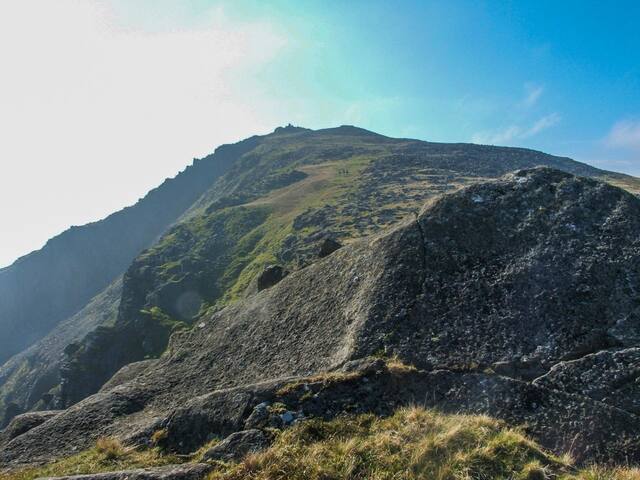
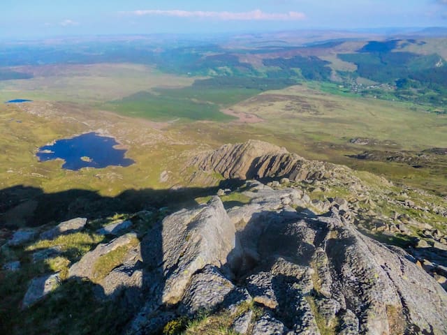
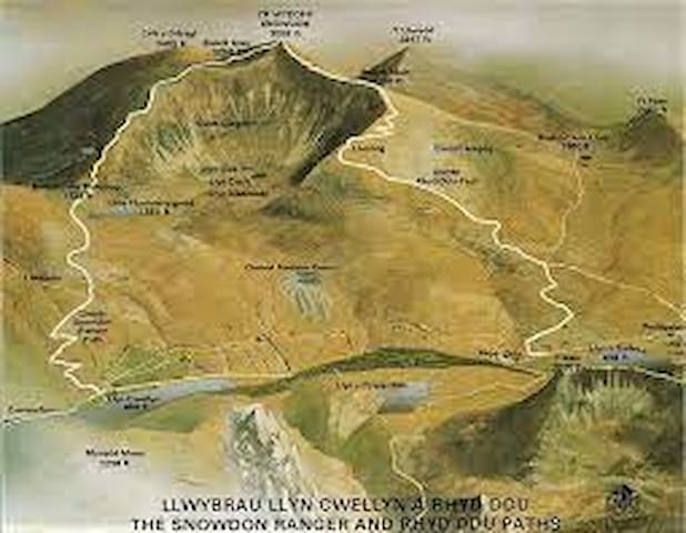
Llanberis Path
Llanberis Path is the easiest and longest of the six main paths to the summit of Snowdon. Originally, tourists were carried up this path on ponies and mules, and to this day it continues to be a pony path.
Distance: 9 miles (there and back)
Total Climb: 975m (3,199 ft)
Difficulty type: Hard/Strenuous
Time: Approx 7 hours (there and back)
Start and Finish: Far end of Victoria Terrace, Llanberis, off the A4086
Map: OS Explorer OL17
Parking: Numerous car parks in Llanberis (LL55 4TD)
Sherpa Bus Stop: Llanberis Interchange
248 íbúar mæla með
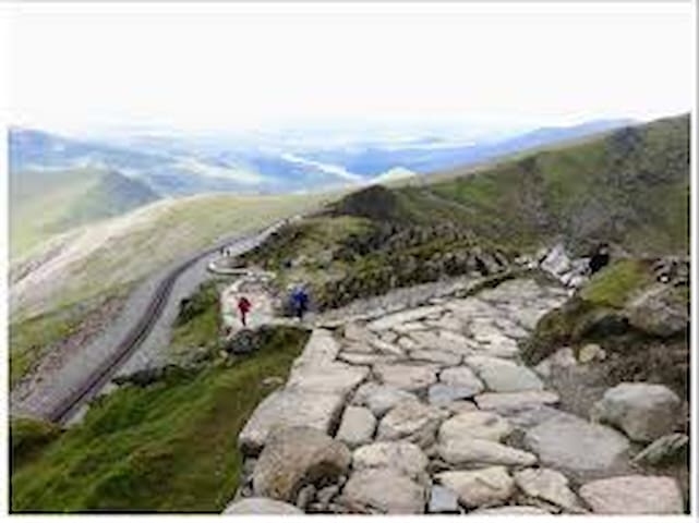
Snowdon
Llanberis Path
Llanberis Path is the easiest and longest of the six main paths to the summit of Snowdon. Originally, tourists were carried up this path on ponies and mules, and to this day it continues to be a pony path.
Distance: 9 miles (there and back)
Total Climb: 975m (3,199 ft)
Difficulty type: Hard/Strenuous
Time: Approx 7 hours (there and back)
Start and Finish: Far end of Victoria Terrace, Llanberis, off the A4086
Map: OS Explorer OL17
Parking: Numerous car parks in Llanberis (LL55 4TD)
Sherpa Bus Stop: Llanberis Interchange
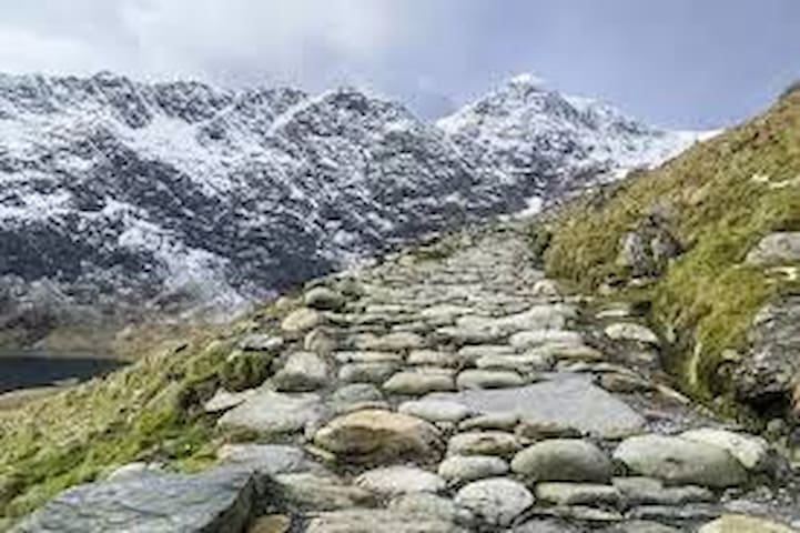
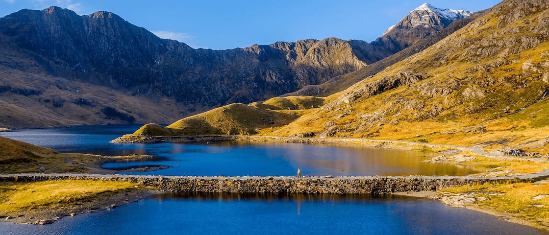
Miners Track
Following the opening of the Llanberis pass in 1832, the Miners Path was built to carry copper from the Britannia Copper Works near Llyn Glaslyn to Pen-y-Pass, where it was then transported to Caernarfon. The mining came to an end in 1916, remains from the work can still be seen on the path to this day.
Distance: 8 miles (there and back)
Total Climb: 723m (2,372 ft)
Difficulty type: Hard/Strenuous
Time: Approx 6 hours (there and back)
Start and Finish: Pen-y-Pass Car Park (LL55 4NY / what3words)
Map: OS Explorer OL17
Parking: Pre-booking is now available for Pen y Pass Car Park. Please note that you cannot park at Pen y Pass without pre-booking a parking space. If the car park is full and you are keen to walk from Pen-y-Pass you can use the Snowdon Sherpa Park and Ride Service running from Nant Peris and Llanberis car parks. Full timetables can be found on the Gwynedd Council website.
Sherpa Bus Stop: Pen-y-Pass Car Park
248 íbúar mæla með
Snowdon
Miners Track
Following the opening of the Llanberis pass in 1832, the Miners Path was built to carry copper from the Britannia Copper Works near Llyn Glaslyn to Pen-y-Pass, where it was then transported to Caernarfon. The mining came to an end in 1916, remains from the work can still be seen on the path to this day.
Distance: 8 miles (there and back)
Total Climb: 723m (2,372 ft)
Difficulty type: Hard/Strenuous
Time: Approx 6 hours (there and back)
Start and Finish: Pen-y-Pass Car Park (LL55 4NY / what3words)
Map: OS Explorer OL17
Parking: Pre-booking is now available for Pen y Pass Car Park. Please note that you cannot park at Pen y Pass without pre-booking a parking space. If the car park is full and you are keen to walk from Pen-y-Pass you can use the Snowdon Sherpa Park and Ride Service running from Nant Peris and Llanberis car parks. Full timetables can be found on the Gwynedd Council website.
Sherpa Bus Stop: Pen-y-Pass Car Park
Watkin Path.
The Watkin Path is a particularly challenging route to the summit of Yr Wyddfa (Snowdon). Walkers considering their first hike up Yr Wyddfa might benefit from trying alternative paths.
Distance: 8 miles (there and back)
Total Climb: 1,015m (3,330 ft)
Difficulty type: Hard/Strenuous
Time: Approx 6 hours (there and back)
Start an Finish: Pont Bethania Bridge Car Park, Nant Gwynant, off the A498 (LL55 4NL / what3words)
Map: OS Explorer OL17
Parking: Pay and Display Pont Bethania Bridge Car Park (LL55 4NL / what3words)
Sherpa Bus Stop: Nant Gwynant Car Park
248 íbúar mæla með
Snowdon
Watkin Path.
The Watkin Path is a particularly challenging route to the summit of Yr Wyddfa (Snowdon). Walkers considering their first hike up Yr Wyddfa might benefit from trying alternative paths.
Distance: 8 miles (there and back)
Total Climb: 1,015m (3,330 ft)
Difficulty type: Hard/Strenuous
Time: Approx 6 hours (there and back)
Start an Finish: Pont Bethania Bridge Car Park, Nant Gwynant, off the A498 (LL55 4NL / what3words)
Map: OS Explorer OL17
Parking: Pay and Display Pont Bethania Bridge Car Park (LL55 4NL / what3words)
Sherpa Bus Stop: Nant Gwynant Car Park
Rhyd Ddu Path
This path used to be known as the Beddgelert Path since it was from this village that walkers started their journey to the summit.
Distance: 8.5 miles (there and back)
Total Climb: 895m (2,936 ft)
Difficulty type: Hard/Strenuous
Time: Approx 6 hours (there and back)
Start and Finish: Rhyd Ddu Car Park (LL54 6TN / what3words)
Map: OS Explorer OL17
Parking: Pay and Display Rhyd Ddu Car Park (LL54 6TN / what3words)
Sherpa Bus Stop: End of Rhyd Ddu Car Par
248 íbúar mæla með
Snowdon
Rhyd Ddu Path
This path used to be known as the Beddgelert Path since it was from this village that walkers started their journey to the summit.
Distance: 8.5 miles (there and back)
Total Climb: 895m (2,936 ft)
Difficulty type: Hard/Strenuous
Time: Approx 6 hours (there and back)
Start and Finish: Rhyd Ddu Car Park (LL54 6TN / what3words)
Map: OS Explorer OL17
Parking: Pay and Display Rhyd Ddu Car Park (LL54 6TN / what3words)
Sherpa Bus Stop: End of Rhyd Ddu Car Par
Snowdon Ranger
The path begins near the ‘Snowdon Ranger’ youth hostel, near Llyn Cwellyn. John Morton the self proclaimed 'Snowdon Ranger' used the path to guide Victorian tourists to the summit. He also opened a tavern where the youth hostel site stands today, and called it the ‘Snowdon Ranger Inn’.
Distance: 8 miles (there and back)
Total Climb: 936m (3,071 ft)
Difficulty type: Hard/Strenuous
Time: Approx 6 hours (there and back)
Start and Finish: Llyn Cwellyn Car Park, off the A4085 (LL54 7YT / what3words)
Map: OS Explorer OL17
Parking: Pay and Display Llyn Cwellyn Car Park ( LL54 7YT / what3words)
Sherpa Bus Stop: Llyn Cwellyn Car Park
248 íbúar mæla með
Snowdon
Snowdon Ranger
The path begins near the ‘Snowdon Ranger’ youth hostel, near Llyn Cwellyn. John Morton the self proclaimed 'Snowdon Ranger' used the path to guide Victorian tourists to the summit. He also opened a tavern where the youth hostel site stands today, and called it the ‘Snowdon Ranger Inn’.
Distance: 8 miles (there and back)
Total Climb: 936m (3,071 ft)
Difficulty type: Hard/Strenuous
Time: Approx 6 hours (there and back)
Start and Finish: Llyn Cwellyn Car Park, off the A4085 (LL54 7YT / what3words)
Map: OS Explorer OL17
Parking: Pay and Display Llyn Cwellyn Car Park ( LL54 7YT / what3words)
Sherpa Bus Stop: Llyn Cwellyn Car Park
Dinorwic quarry is a large former slate quarry, now home to the Welsh National Slate Museum, located between the villages of Llanberis and Dinorwig in Wales.
Enjoy this 12.2-km circular trail near Llanberis, Gwynedd. Generally considered a challenging route, it takes an average of 6 h 1 min to complete. This is a very popular area for birding, hiking, and walking, so you'll likely encounter other people while exploring. Dogs are welcome and may be off-lead in some areas.
If you want to do the Dinorwic Quarry hike you'll want to park in the Slate Museum carpark (Llanberis, Caernarfon LL55 4TY)
There's plenty of carparking there.
7 íbúar mæla með
Dinorwig Quarry
Dinorwic quarry is a large former slate quarry, now home to the Welsh National Slate Museum, located between the villages of Llanberis and Dinorwig in Wales.
Enjoy this 12.2-km circular trail near Llanberis, Gwynedd. Generally considered a challenging route, it takes an average of 6 h 1 min to complete. This is a very popular area for birding, hiking, and walking, so you'll likely encounter other people while exploring. Dogs are welcome and may be off-lead in some areas.
If you want to do the Dinorwic Quarry hike you'll want to park in the Slate Museum carpark (Llanberis, Caernarfon LL55 4TY)
There's plenty of carparking there.
Where is it? Betws y Coed in the beautiful Conwy Valley where the Afon (River) Conwy meets the Afon Llugwy.
How long will it take ? : The short walk can be completed in less than half an hour. The longer circular walk isless than. 2 miles . You could walk it in an hour but allow time to enjoy the beautiful scenery.
What's the attraction? : Glorious riverside walk with a nice new wooden walkway that opens up part of the walk for wheelchair users.
Essentials : Good walking boots would help on the muddy stretches.
Rating : Easy. Suitable for all the family.
Car Parking : Parking is available at the Pont y Pair Car Park. (Pay and Display)
Facilities : Toilets are available at the Car Park. Fish and Chips are available to eat in or take away at the Pont y Pair chip shop.
Afon Llugwy
Where is it? Betws y Coed in the beautiful Conwy Valley where the Afon (River) Conwy meets the Afon Llugwy.
How long will it take ? : The short walk can be completed in less than half an hour. The longer circular walk isless than. 2 miles . You could walk it in an hour but allow time to enjoy the beautiful scenery.
What's the attraction? : Glorious riverside walk with a nice new wooden walkway that opens up part of the walk for wheelchair users.
Essentials : Good walking boots would help on the muddy stretches.
Rating : Easy. Suitable for all the family.
Car Parking : Parking is available at the Pont y Pair Car Park. (Pay and Display)
Facilities : Toilets are available at the Car Park. Fish and Chips are available to eat in or take away at the Pont y Pair chip shop.
A walk from the middle of Betws Y Coed to the Fairy Glen gorge. Walking along lanes and tracks, taking in great views of the River Conwy and the Fairy Glen gaorge and area. Note there is a £1 entrance fee to walk down to the gorge.
Park at any car park in Betws Y Coed
Total distance: 3.5 Miles
Total time: 2 hrs
17 íbúar mæla með
Ffos Anoddun
A5A walk from the middle of Betws Y Coed to the Fairy Glen gorge. Walking along lanes and tracks, taking in great views of the River Conwy and the Fairy Glen gaorge and area. Note there is a £1 entrance fee to walk down to the gorge.
Park at any car park in Betws Y Coed
Total distance: 3.5 Miles
Total time: 2 hrs
Parking: 3AQ, B4410, Blaenau Ffestiniog
Llyn Mair is a 14-acre artificial lake near Maentwrog, in Gwynedd in North Wales. It lies in the area of Tan-y-Bwlch, a little above Plas Tan-y-Bwlch, and is in the catchment area of the River Dwyryd. It was created by William Edward Oakeley as a 21st birthday present for his daughter Mair and as a water supply.
9 íbúar mæla með
Llyn Mair
Parking: 3AQ, B4410, Blaenau Ffestiniog
Llyn Mair is a 14-acre artificial lake near Maentwrog, in Gwynedd in North Wales. It lies in the area of Tan-y-Bwlch, a little above Plas Tan-y-Bwlch, and is in the catchment area of the River Dwyryd. It was created by William Edward Oakeley as a 21st birthday present for his daughter Mair and as a water supply.
Cwm Mynach is a hidden valley running through the wild and beautiful Rhinogydd mountain range. Follow a woodland pathway and discover breathtaking views of lakes, streams and mountains while relishing the tranquillity of Snowdonia’s best kept secret.
Explore diverse habitats, immerse yourself in the stillness of legions of conifer, and see the stunning upland lake, Llyn Cwm Mynach
Features
Parking nearby
Public access
Autumn colour
Marshland
Moorland
DIRECTIONS:
From the A496 Llanelltyd to Barmouth road, take the uphill turn opposite the toll bridge that connects the A496 to Penmaenpool, then proceed uphill along a steep and narrow minor road for about one and a half miles through the village of Taicynhaeaf.
PARKING:
There is space for a small number of vehicles on the right before the road bride, by the main entrance to the wood.
If continuing uphill to the old lay-by at the end of the tarmac road, please take care to shut all gates and not obstruct access.
Parking is also available at a number of locations along the A496 Dolgellau-Barmouth road, including the National Park's Fiddler's Elbow picnic site, where an information panel details a day walk through Cwm Mynach and the RSPB’s Garth Gell reserve.
Llyn Cwm-mynach, Barmouth LL40 2TU, UK
Cwm Mynach is a hidden valley running through the wild and beautiful Rhinogydd mountain range. Follow a woodland pathway and discover breathtaking views of lakes, streams and mountains while relishing the tranquillity of Snowdonia’s best kept secret.
Explore diverse habitats, immerse yourself in the stillness of legions of conifer, and see the stunning upland lake, Llyn Cwm Mynach
Features
Parking nearby
Public access
Autumn colour
Marshland
Moorland
DIRECTIONS:
From the A496 Llanelltyd to Barmouth road, take the uphill turn opposite the toll bridge that connects the A496 to Penmaenpool, then proceed uphill along a steep and narrow minor road for about one and a half miles through the village of Taicynhaeaf.
PARKING:
There is space for a small number of vehicles on the right before the road bride, by the main entrance to the wood.
If continuing uphill to the old lay-by at the end of the tarmac road, please take care to shut all gates and not obstruct access.
Parking is also available at a number of locations along the A496 Dolgellau-Barmouth road, including the National Park's Fiddler's Elbow picnic site, where an information panel details a day walk through Cwm Mynach and the RSPB’s Garth Gell reserve.
This spectacular high waterfall, one of the hidden gems of Wales, gushes down the heather clad slopes of the valley of Afon Eiddew, near Lake Vyrnwy, known locally as Pistyll Rhyd-y-meincau, it is commonly known as Rhiwargor Waterfall.
One of the highest of the falls surrounding Lake Vyrnwy, the waterfall is situated at the northern end of the lake and can be reached by a short walk from the Rhiwargor Waterfall car park.
One of the highest of the falls surrounding Lake Vyrnwy, the waterfall is situated at the northern end of the lake and can be reached by a short walk from the Rhiwargor Waterfall car park.
Either retrace your steps to return or take the forest track to return to the car park.
Rhiwargor Waterfall
This spectacular high waterfall, one of the hidden gems of Wales, gushes down the heather clad slopes of the valley of Afon Eiddew, near Lake Vyrnwy, known locally as Pistyll Rhyd-y-meincau, it is commonly known as Rhiwargor Waterfall.
One of the highest of the falls surrounding Lake Vyrnwy, the waterfall is situated at the northern end of the lake and can be reached by a short walk from the Rhiwargor Waterfall car park.
One of the highest of the falls surrounding Lake Vyrnwy, the waterfall is situated at the northern end of the lake and can be reached by a short walk from the Rhiwargor Waterfall car park.
Either retrace your steps to return or take the forest track to return to the car park.
Distance from Cabins: 18 min (12.9 mi)
via A470
Route type: Circular route
Length: 4km
Duration: 1 Hrs
Path Popularity: Not popular
The Torrent Walk is a path on the outskirts of Dolgellau and is one of the more popular routes in the area. This walk will lead you under a woodland canopy, along the Clywedog river and past hidden industrial remains.
The walk’s name likely derives from the many striking views of the Clywedog river as it cascades down the gorge.
Why this path?
The gorge is home to a wealth of wildlife, including otters, dormice, lesser horseshoe bats, and an important collection of unique plants such as lichen, ferns, mushrooms, and liverwort.
Torrent walk
Distance from Cabins: 18 min (12.9 mi)
via A470
Route type: Circular route
Length: 4km
Duration: 1 Hrs
Path Popularity: Not popular
The Torrent Walk is a path on the outskirts of Dolgellau and is one of the more popular routes in the area. This walk will lead you under a woodland canopy, along the Clywedog river and past hidden industrial remains.
The walk’s name likely derives from the many striking views of the Clywedog river as it cascades down the gorge.
Why this path?
The gorge is home to a wealth of wildlife, including otters, dormice, lesser horseshoe bats, and an important collection of unique plants such as lichen, ferns, mushrooms, and liverwort.
Walking
DifficultyModerate*
Dog friendly**
Duration3 hours to 4 hours3 hours - 4 hours
Access: Challenging***
DistanceMiles: 6.5 (km: 10.4) Full trail
*A steady climb over rough ground. For further details, please see Terrain section.
**Dogs welcome on leads. For further details, please see section marked Facilities.
***Uneven surface and steps throughout the trail.
You’ll surround yourself with the stunning scenic beauty of the Nant Gwynant Valley on this walk. Starting from the National Trust’s Craflwyn car parka near Beddgelert, the 6.6-mile/10.4km route combines lakeside terrain with some higher-level walking on the lower slopes of Snowdon.
The early part of the walk sees you climbing through a landscape of waterfalls and woodland, where you’ll encounter carpets of bluebells in early summer. Watch out for the oversized Giant’s Chair, a great place to stop for a breather and take in the views of Moel Hebog, Sygun Copper Mine and the hill of Dinas Emrys, legendary location of a battle between two mighty dragons.
After crossing through rugged heathland beneath Yr Afan at Snowdon’s base, you’ll descend through the oak woodlands of Parc Hafod y Llan and past the tumbling waterfalls of Afon Cwm Llyn. Once you’ve returned to the bottom of the valley, make your way back to your start point along the banks of the idyllic glacial lake of Llyn Dinas.
Llyn Dinas
Walking
DifficultyModerate*
Dog friendly**
Duration3 hours to 4 hours3 hours - 4 hours
Access: Challenging***
DistanceMiles: 6.5 (km: 10.4) Full trail
*A steady climb over rough ground. For further details, please see Terrain section.
**Dogs welcome on leads. For further details, please see section marked Facilities.
***Uneven surface and steps throughout the trail.
You’ll surround yourself with the stunning scenic beauty of the Nant Gwynant Valley on this walk. Starting from the National Trust’s Craflwyn car parka near Beddgelert, the 6.6-mile/10.4km route combines lakeside terrain with some higher-level walking on the lower slopes of Snowdon.
The early part of the walk sees you climbing through a landscape of waterfalls and woodland, where you’ll encounter carpets of bluebells in early summer. Watch out for the oversized Giant’s Chair, a great place to stop for a breather and take in the views of Moel Hebog, Sygun Copper Mine and the hill of Dinas Emrys, legendary location of a battle between two mighty dragons.
After crossing through rugged heathland beneath Yr Afan at Snowdon’s base, you’ll descend through the oak woodlands of Parc Hafod y Llan and past the tumbling waterfalls of Afon Cwm Llyn. Once you’ve returned to the bottom of the valley, make your way back to your start point along the banks of the idyllic glacial lake of Llyn Dinas.
The legendary trail of Dinas Emrys
Enjoy a pleasant walk past waterfalls and through beautiful oak woodland to reach this summit of this legendary hill, where Merlin once trod and where a dragon still sleeps. At the top you’ll find remains of a square tower and defensive ramparts belonging to the ancient princes of Gwynedd.
Walking
DifficultyModerate*
Dog friendly**
Duration1 hour 30 mins to 2 hours 30 mins1 hour 30 mins - 2 hours 30 mins
Access: Challenging***
DistanceMiles: 2.2 (km: 3.52) Full trail
*Mainly gentle uphill walk with steep and rocky section towards the end. For further details, please see Terrain section.
**Dogs welcome on leads. For further details, please see section marked Facilities.
***Uneven surfaces, steps and stiles throughout the trail. For further information, please see section marked Access.
Dinas Emrys
The legendary trail of Dinas Emrys
Enjoy a pleasant walk past waterfalls and through beautiful oak woodland to reach this summit of this legendary hill, where Merlin once trod and where a dragon still sleeps. At the top you’ll find remains of a square tower and defensive ramparts belonging to the ancient princes of Gwynedd.
Walking
DifficultyModerate*
Dog friendly**
Duration1 hour 30 mins to 2 hours 30 mins1 hour 30 mins - 2 hours 30 mins
Access: Challenging***
DistanceMiles: 2.2 (km: 3.52) Full trail
*Mainly gentle uphill walk with steep and rocky section towards the end. For further details, please see Terrain section.
**Dogs welcome on leads. For further details, please see section marked Facilities.
***Uneven surfaces, steps and stiles throughout the trail. For further information, please see section marked Access.
Gelert's grave walk
This circular riverside walk will give you an insight into the legend of Gelert and Prince Llywelyn which gave the village its name, and why Beddgelert became so popular with early travel writers such as Thomas Pennant and artists like JMW Turner.
Trail information summary
Walking
DifficultyEasy
Dog friendly*
Duration 40 mins to 1 hour 40 mins - 1 hour
Access: Easy**
Miles:1 km: 1.6) Full trail
*Dogs are welcome in Snowdonia in general, but please keep them under control. For further details, please see section marked Facilities.
**Walk suitable for all including pushchairs and wheelchairs. For further details, please see section marked Access.
9 íbúar mæla með
Gelert's Grave
Gelert's grave walk
This circular riverside walk will give you an insight into the legend of Gelert and Prince Llywelyn which gave the village its name, and why Beddgelert became so popular with early travel writers such as Thomas Pennant and artists like JMW Turner.
Trail information summary
Walking
DifficultyEasy
Dog friendly*
Duration 40 mins to 1 hour 40 mins - 1 hour
Access: Easy**
Miles:1 km: 1.6) Full trail
*Dogs are welcome in Snowdonia in general, but please keep them under control. For further details, please see section marked Facilities.
**Walk suitable for all including pushchairs and wheelchairs. For further details, please see section marked Access.
DOG FRIENDLY WALK
Parking: Free car park. Beddgelert Forest Car Park Just off the A4085 beside Glan-y-gors Holiday Cottage
Average walking time: 1 hour 45 minutes
Distance: 2.7 miles / 4.4 km
Type: Circular route
Rating: Easy
Follow the red footprint way-marked route titled Llyn Llynwelyn walk.
This circular route follows a fairly flat and even path whilst also hosting an array of places for the dog to explore such as the woodland and the river. It is pretty much guaranteed to be quiet too.
Beddgelert Forest, Caernarfon LL54, UK
DOG FRIENDLY WALK
Parking: Free car park. Beddgelert Forest Car Park Just off the A4085 beside Glan-y-gors Holiday Cottage
Average walking time: 1 hour 45 minutes
Distance: 2.7 miles / 4.4 km
Type: Circular route
Rating: Easy
Follow the red footprint way-marked route titled Llyn Llynwelyn walk.
This circular route follows a fairly flat and even path whilst also hosting an array of places for the dog to explore such as the woodland and the river. It is pretty much guaranteed to be quiet too.
Length0.6 kmElevation gain31 mRoute typeCircular
Get to know this 0.6-km circular trail near Betws-y-Coed, Conwy. Generally considered a moderately challenging route, it takes an average of 14 min to complete. This is a popular trail for hiking and walking, but you can still enjoy some solitude during quieter times of day. The trail is open year-round and is beautiful to visit anytime. Dogs are welcome, but must be on a lead.
15 íbúar mæla með
Rhaeadr Y Graig Lwyd
A5Length0.6 kmElevation gain31 mRoute typeCircular
Get to know this 0.6-km circular trail near Betws-y-Coed, Conwy. Generally considered a moderately challenging route, it takes an average of 14 min to complete. This is a popular trail for hiking and walking, but you can still enjoy some solitude during quieter times of day. The trail is open year-round and is beautiful to visit anytime. Dogs are welcome, but must be on a lead.
Food scene
Service options: Dine-in · Takeaway · No delivery
Address: Trawsfynydd, Blaenau Ffestiniog LL41 4SE
The Cross Foxes Hotel
Service options: Dine-in · Takeaway · No delivery
Address: Trawsfynydd, Blaenau Ffestiniog LL41 4SE
Service options: Dine-in · Takeaway · No delivery
Address: Coed-Y-Llwyn, Gellilydan, Blaenau Ffestiniog LL41 4EN
7 íbúar mæla með
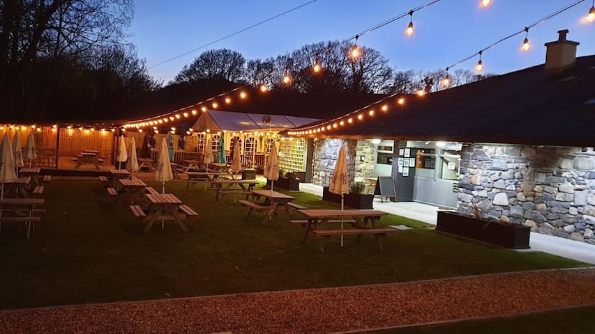
Bryn Arms
Coed-Y-LlwynService options: Dine-in · Takeaway · No delivery
Address: Coed-Y-Llwyn, Gellilydan, Blaenau Ffestiniog LL41 4EN
Service options: Dine-in · Takeaway · No delivery
Address: Power Station, A496, Blaenau Ffestiniog LL41 3TP
Hours:
Thursday 9am–5pm
Friday 9am–5pm
Saturday 9am–5pm
Sunday 9am–5pm
Monday9am–5pm
Tuesday 9am–5pm
Wednesday 9am–5pm
8 íbúar mæla með
Lakeside Cafe
A496Service options: Dine-in · Takeaway · No delivery
Address: Power Station, A496, Blaenau Ffestiniog LL41 3TP
Hours:
Thursday 9am–5pm
Friday 9am–5pm
Saturday 9am–5pm
Sunday 9am–5pm
Monday9am–5pm
Tuesday 9am–5pm
Wednesday 9am–5pm
Service options: Dine-in · Takeaway · No delivery
Address: 36 High St, Blaenau Ffestiniog LL41 3AA
Hours:
Thursday 5–10pm
Friday 5–10pm
Saturday 5–10pm
Sunday 5–10pm
Monday5–10pm
Tuesday 5–10pm
Wednesday 5–10pm
De Niros
36 High StService options: Dine-in · Takeaway · No delivery
Address: 36 High St, Blaenau Ffestiniog LL41 3AA
Hours:
Thursday 5–10pm
Friday 5–10pm
Saturday 5–10pm
Sunday 5–10pm
Monday5–10pm
Tuesday 5–10pm
Wednesday 5–10pm
Indian restaurant
Service options: Dine-in · Takeaway · No delivery
Address: 38 High St, Blaenau Ffestiniog LL41 3AE
Hours:
Thursday 5–10pm
Friday 5–10pm
Saturday 5–10pm
Sunday 5–10pm
Monday5–10pm
Tuesday 5–10pm
Wednesday 5–10pm
Red Chillis
38 High StIndian restaurant
Service options: Dine-in · Takeaway · No delivery
Address: 38 High St, Blaenau Ffestiniog LL41 3AE
Hours:
Thursday 5–10pm
Friday 5–10pm
Saturday 5–10pm
Sunday 5–10pm
Monday5–10pm
Tuesday 5–10pm
Wednesday 5–10pm
Fish & chips shop
Service options: Takeaway · No-contact delivery · No dine-in
Address: Unit 3 High St, Blaenau Ffestiniog LL41 3ES
Hours:
Thursday 11:30am–1:30pm, 4–8:30pm
Friday 11:30am–1:30pm, 4–8:30pm
Saturday 11:30am–1:30pm, 4–8:30pm
Sunday 4–8:30pm
Monday4–8:30pm
Tuesday 4–8:30pm
Wednesday 4–8:30pm
Trish & Chips
Unit 3 High StFish & chips shop
Service options: Takeaway · No-contact delivery · No dine-in
Address: Unit 3 High St, Blaenau Ffestiniog LL41 3ES
Hours:
Thursday 11:30am–1:30pm, 4–8:30pm
Friday 11:30am–1:30pm, 4–8:30pm
Saturday 11:30am–1:30pm, 4–8:30pm
Sunday 4–8:30pm
Monday4–8:30pm
Tuesday 4–8:30pm
Wednesday 4–8:30pm
Vegan restaurant
Down-to-earth restaurant offering plant-based sandwiches, wings & flatbreads, plus specialty drinks.
Service options: Dine-in · Kerbside pickup · No delivery
Address: 21 High St, Penrhyndeudraeth LL48 6BN
Hours:
Thursday 8:30am–4:30pm
Friday 8:30am–4:30pm
Saturday 8:30am–4:30pm
Sunday 8:30am–4:30pm
Monday8:30am–4:30pm
Tuesday 8:30am–4:30pm
Wednesday 8:30am–4:30pm
19 íbúar mæla með
The Eating Gorilla
21 High St
Vegan restaurant
Down-to-earth restaurant offering plant-based sandwiches, wings & flatbreads, plus specialty drinks.
Service options: Dine-in · Kerbside pickup · No delivery
Address: 21 High St, Penrhyndeudraeth LL48 6BN
Hours:
Thursday 8:30am–4:30pm
Friday 8:30am–4:30pm
Saturday 8:30am–4:30pm
Sunday 8:30am–4:30pm
Monday8:30am–4:30pm
Tuesday 8:30am–4:30pm
Wednesday 8:30am–4:30pm
Service options: Dine-in · No takeaway · No delivery
Address: 16 Lombard St, Porthmadog LL49 9AP
Hours:
Thursday 5:30–8:30pm
Friday 5:30–8:30pm
Saturday 5:30–8:30pm
Sunday 5:30–8:30pm
Monday5:30–8:30pm
Tuesday 5:30–8:30pm
Wednesday 5:30–8:30pm
13 íbúar mæla með
Yr Hen Fecws Restaurant and B&B
16 Lombard StService options: Dine-in · No takeaway · No delivery
Address: 16 Lombard St, Porthmadog LL49 9AP
Hours:
Thursday 5:30–8:30pm
Friday 5:30–8:30pm
Saturday 5:30–8:30pm
Sunday 5:30–8:30pm
Monday5:30–8:30pm
Tuesday 5:30–8:30pm
Wednesday 5:30–8:30pm
Mexican restaurant
Service options: Dine-in · Takeaway · No delivery
Address: Siop Antur Stiniog Unit 1 and 2, High St, Blaenau Ffestiniog LL41 3ES
Hours:
Thursday 5–9pm
Friday 5–9pm
Saturday 5–9pm
Sunday Closed
MondayClosed
Tuesday Closed
Wednesday Closed
Burrito Blasus
Mexican restaurant
Service options: Dine-in · Takeaway · No delivery
Address: Siop Antur Stiniog Unit 1 and 2, High St, Blaenau Ffestiniog LL41 3ES
Hours:
Thursday 5–9pm
Friday 5–9pm
Saturday 5–9pm
Sunday Closed
MondayClosed
Tuesday Closed
Wednesday Closed
Restaurant
Service options: Dine-in · No takeaway · No delivery
Address: 12-16 Market Square, Tremadog, Porthmadog LL49 9RB
Hours:
Thursday 5–9pm
Friday 5–9pm
Saturday 5–9pm
Sunday 12–3pm
MondayClosed
Tuesday 5–9pm
Wednesday 5–9pm
37 íbúar mæla með
Y Sgwâr
12-16 Market SquareRestaurant
Service options: Dine-in · No takeaway · No delivery
Address: 12-16 Market Square, Tremadog, Porthmadog LL49 9RB
Hours:
Thursday 5–9pm
Friday 5–9pm
Saturday 5–9pm
Sunday 12–3pm
MondayClosed
Tuesday 5–9pm
Wednesday 5–9pm
Cafe
Service options: Dine-in · Takeaway · No delivery
Address: Y Garreg Shop and Kitchen, Llanfrothen, Garreg, Penrhyndeudraeth LL48 6AQ
Y Garreg Shop and Kitchen
opening hours
Thursday 8am–9pm
Friday 8am–9pm
Saturday 8am–9pm
Sunday Closed
Monday
(Summer Bank Holiday)
Closed
Tuesday 8am–5pm
Wednesday 8am–5pm
10 íbúar mæla með
Y Garreg Shop and Kitchen
Cafe
Service options: Dine-in · Takeaway · No delivery
Address: Y Garreg Shop and Kitchen, Llanfrothen, Garreg, Penrhyndeudraeth LL48 6AQ
Y Garreg Shop and Kitchen
opening hours
Thursday 8am–9pm
Friday 8am–9pm
Saturday 8am–9pm
Sunday Closed
Monday
(Summer Bank Holiday)
Closed
Tuesday 8am–5pm
Wednesday 8am–5pm
Parking is free, a traditional pub that features countryside views and a fireplace, and also offers lunch and dinner, as well as wine and regional ales
.Address: Maentwrog, Blaenau Ffestiniog LL41 4HN
33 íbúar mæla með
The Grapes Hotel
Parking is free, a traditional pub that features countryside views and a fireplace, and also offers lunch and dinner, as well as wine and regional ales
.Address: Maentwrog, Blaenau Ffestiniog LL41 4HN
Italian restaurant
Service options: Dine-in · No delivery
Address: Portmeirion LL48 6ER
Hours:
Thursday 9:30am–9pm
Friday 9:30am–9pm
Saturday 9:30am–9pm
Sunday 9:30am–9pm
Monday9:30am–9pm
Tuesday 9:30am–9pm
Wednesday 9:30am–9pm
Caffi Glas
Italian restaurant
Service options: Dine-in · No delivery
Address: Portmeirion LL48 6ER
Hours:
Thursday 9:30am–9pm
Friday 9:30am–9pm
Saturday 9:30am–9pm
Sunday 9:30am–9pm
Monday9:30am–9pm
Tuesday 9:30am–9pm
Wednesday 9:30am–9pm
Railway-themed venue in an old train shed featuring British fare, local ales & terrace seating.
Service options: Dine-in · Takeaway · No delivery
Address: Harbour Station, 113 Britannia Terrace, Porthmadog LL49 9NF
Hours:
Thursday 9am–10pm
Friday 9am–10pm
Saturday 9am–11pm
Sunday 9am–6am
Monday9am–10pm
Tuesday 9am–10pm
Wednesday 9am–10pm
Spooner's Cafe, Bar and Grill
113 Britannia TerraceRailway-themed venue in an old train shed featuring British fare, local ales & terrace seating.
Service options: Dine-in · Takeaway · No delivery
Address: Harbour Station, 113 Britannia Terrace, Porthmadog LL49 9NF
Hours:
Thursday 9am–10pm
Friday 9am–10pm
Saturday 9am–11pm
Sunday 9am–6am
Monday9am–10pm
Tuesday 9am–10pm
Wednesday 9am–10pm
Service options: Dine-in · Takeaway · No delivery
Address: Penmaenpool, Dolgellau LL40 1YD
Hours:
Thursday 10am–11pm
Friday 10am–11pm
Saturday 10am–11pm
Sunday 11am–10pm
Monday10am–11pm
Tuesday 10am–11pm
Wednesday 10am–11pm
27 íbúar mæla með
George III Hotel
Service options: Dine-in · Takeaway · No delivery
Address: Penmaenpool, Dolgellau LL40 1YD
Hours:
Thursday 10am–11pm
Friday 10am–11pm
Saturday 10am–11pm
Sunday 11am–10pm
Monday10am–11pm
Tuesday 10am–11pm
Wednesday 10am–11pm
Address: Maentwrog, Blaenau Ffestiniog LL41 3YU
The Oakeley Arms is a free house and has a fully stocked bar with a variety of Real Ales, Lagers and Ciders. They also stock a selection of Welsh Gins, as well as Welsh whiskeys, wines and liqueurs.
The bar menu offers a delicious range of home-cooked meals and specials, with Vegetarian/Vegan options and children’s meals to keep even the little ones happy.
24 íbúar mæla með
Oakeley Arms Hotel
Address: Maentwrog, Blaenau Ffestiniog LL41 3YU
The Oakeley Arms is a free house and has a fully stocked bar with a variety of Real Ales, Lagers and Ciders. They also stock a selection of Welsh Gins, as well as Welsh whiskeys, wines and liqueurs.
The bar menu offers a delicious range of home-cooked meals and specials, with Vegetarian/Vegan options and children’s meals to keep even the little ones happy.
Yr Unicorn
Smithfield SquareAddress: Smithfield Square, Dolgellau LL40 1ES