
Rob & Angela’s guidebook
Neighbourhoods
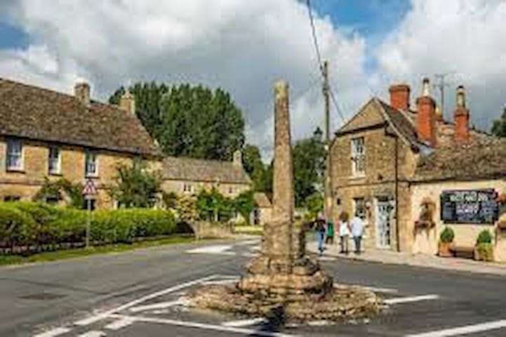
Welcome to South Cerney
South Cerney is a thriving Cotswold village a few miles from Cirencester, Gloucestershire.The has a range of local amenities including a Post Office, Co-Op and One Stop general stores, ladies hairdressers, Indian restaurant/takeaway, fish and chip shop, a pharmacy and a dental surgery. There are also 3 public houses in South Cerney, The Old George, The Royal Oak and The Eliot Arms (which also has accommodation).
You can also have a round of golf at the 18 hole South Cerney golf course on the edge of South Cerney village, near to South Cerney Airfield.
South Cerney is in the heart of the Cotswold Water Park and only a stone’s throw from lakes where you can undertake many water sport activities as well as fishing.
Cerney Wick is also just a short distance from South Cerney and is home to The Crown public house and Trinity Church.
Cotswold Water Park
The Cotswold Water Park is made up of over 140 lakes that have been created by gravel extraction. Thousands of years ago an ice sheet that covered the Midlands began to melt, turning into rivers. These rivers and streams took with them sand and gravel, depositing them up to 20 feet thick in places.
These sand and gravel deposits lay relatively undisturbed until people began to excavate these resources in the early 1920s. As a result the area was left scarred with huge hollows and pits. Water began to naturally fill these pits, turning them into freshwater lakes, and the area now known as the Cotswold Water Park was born.
Over recent years these lakes have increasing become popular places where anglers can fish, water skiers and jet skiers can ski, sailors can sail their yachts and walkers can enjoy miles of countryside walks.
The Cotswold Water Park has become a renowned conservation area, several of the lakes are now Sites of Scientific Interest, and large numbers of waterfowl breed and winter here.
In recent years holiday villages and holiday homes and housing developments such as those found at the Watermark Club and the Lower Mill Estate have sprung up around some of the lakes offering a range of differing accommodation including wooden chalets with gardens bordering the lakes.
Hoburne Cotswold is a popular static caravan site on the edge of South Cerney village. Well worth a visit with it's indoor and outdoor swimming pool.
As a result of this explosion of activity over recent years, the local villages have become more popular and South Cerney especially has thrived. It was a pretty enough village in its own right, but has always been in the shadows of its more famous neighbour, Cirencester.
South Cerney Church and St Edwards College
All Hallows Church, South Cerney, contains a beautiful carved wooden head and foot of Christ, taken from a crucifix in Compostela, dating from the 12th Century.
At the end of Silver Street in South Cerney is St Edwards College, founded by Anne Edwards in 1834 (the primary school in South Cerney is called Anne Edwards School) to house the widows of clergymen. And in nearby Station Road, an attractive row of gabled cottages dates from the 16th and 17th Centuries.
The remains of the some of the old railway line can also be found in this area of the village.
A Thriving Village
All in all, South Cerney is an area to watch. Residents and visitors have seen its popularity and nearby facilities increase greatly over recent years but South Cerney itself still has the charm of a Cotswold village. Industrial areas have sprung up on the outskirts of South Cerney, bringing even more requirements for housing and a large estate was built on the land sold by Aggregate Industries some years ago.
And with the ever-increasing interest and demand for "leisure pursuits" being as strong as ever, it seems that the area will continue to grow in popularity for many years to come.
Ashton Keynes
The first settlement on the infant River Thames, Ashton Keynes reputedly has more bridges over the Thames than London.
Offering a wonderful, picturesque Church Walk, and the river banks on the High Road are bedecked with hundreds of daffodils in the Spring. This friendly village is home to approximately 1500 people, with a vibrant primary school, a community run village shop, a Norman church and excellent pub, Ashton Keynes is certainly a lovely place to explore.
Cricklade
The first Town on the Thames, Cricklade is the southern gateway to the Cotswold Water Park with lots to offer visitors. Historical and pretty and somewhere everyone can be assured of a warm welcome.
Steeped in tradition with one of the country’s last remaining Manorial Court Leets, it boasts 112 listed buildings and all mainly on its attractive High Street. Cricklade is also designated as area of Special Archaeological Significance and described as the best preserved example of a Saxon new town.
Walkers are particularly well catered for with a range of options from a Heritage Trail around the town centre to the 184 mile Thames Path National Trail.
Just on the edge of the town is North Meadow, a National Nature Reserve and one of the finest examples of a lowland hay meadow in Europe with beautiful wildflowers and the rare snakeshead fritillaries – a focal point for many hundreds of visitors each Spring.
With a strong sense of community spirit, residents are rightly proud of their town and were delighted to have their efforts recognised in 2011 when Cricklade was named RHS Britain in Bloom Champion of Champions. It’s no wonder people return again and again.
Fairford
Fairford is a small market town in Gloucestershire situated on the River Coln between Cirencester and Lechlade. It is famed for St Mary’s Church and the most complete set of medieval stained-glass windows in the world.
Fairford Mill and Oxpens, the River Coln walks, the Market Place and High Street, lined with beautiful Grade 2 listed buildings like the Community Centre are all part of the town’s attraction.
The name of the town is the modern version of its Anglo-Saxon name, Fagrinforda, which means fair, in the sense of being good, and ford, a place to cross a river. The River Coln flows rapidly from the Cotswold hills to the infant Thames, four miles away at Inglesham. There it almost doubles the size of the River Thames. At Fairford, however, in the past, it broadened out, became shallower and slower and was therefore easier to cross. Today there are two bridges and the river is channelled under them.
Recent excavations on the west of Fairford have revealed evidence of Iron Age, Roman and Saxon settlements which suggests that the site was occupied from 400 BC to 800 AD. As well as Iron Age buildings, a large Roman cemetery remains of a Roman farmstead and Saxon grubenhauser were found.
Lechlade
Lechlade gets its name from the River Leach which joins the Thames just east of the town.
From the earliest days, it was an ideal location for a settlement as the rivers were a source of food and an easy way to travel.
There is evidence of a henge monument dating back to 2500BC and there are Bronze Age barrows dating back to 1800BC. By the early Iron Age, there was a large settlement with grain stores indicating a farming community.
During Roman times there was a substantial presence around Lechlade. An archaeological excavation of Butlers Field in 1985 revealed a Saxon burial ground dating to a period between 500 and 700AD. Many of the artefacts are now on display in the Corinium Museum in Cirencester and include beads, pins, brooches and rings.
Somerford Keynes
Lying very close to the river Thames, and the long distance Thames Path, the peaceful village of Somerford Keynes can trace its history back to a charter of 685 AD, but archaeological investigation in advance of gravel extraction has shown evidence of Iron Age and Roman occupation.
The manor house dates back to the 15th century, sited next to the All Saints Anglo Saxon Church which has the possible remains of an 8th century church revealed in a doorway.
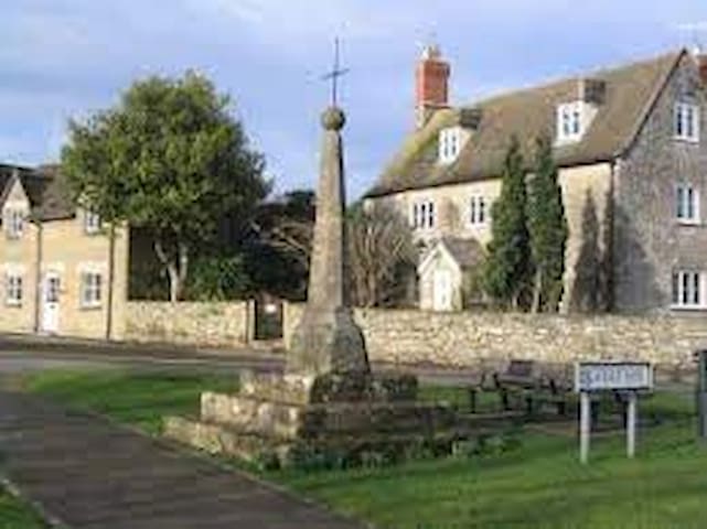
South Cerney
South Cerney is a village and civil parish in the Cotswold district of Gloucestershire, 3 miles south of Cirencester and close to the border with Wiltshire. Founded in 999 by Saxon settlers, with a charter by King Aethelred II, it now has a population of more than 3000.The River churn flows through the heart of the village, surrounded by small but thriving shops and pubs.
A delightful Cotswold village, South Cerney was winner of the best kept village award in 2001. Worth a visit are the narrow lanes around the oldest part of the village, such as Bow Wow, Church Lane and School Lane, with All Hallows Church, the Old Vicarage and the Manor House, along with some beautifully preserved 16th and 17th century buildings.
Guided Walks
The Civic Society offers guided walks on Saturdays and Sundays from 6th April to 27th October and on Tuesdays and Thursdays from 16th July to 12th September. Walks start at 2.00pm outside the Parish Church and last about 75 minutes. Knowledgeable Town Guides explain the history of the town and point out significant buildings. The cost is £3.00pp – children and students are free.
Walks can also be booked for groups at any time of the year.
More details can be found on the Civic Society website
The Whereat Trail
Why not explore Cirencester’s hidden treasure – the Roman Amphitheatre? Pick up the Whereat Trail leaflet from our Local Information Centre. The trail directs visitors to the Amphitheatre from the Corinium Museum, providing interesting facts along the way.
The Trail commemorates former Mayor and community stalwart Norman Whereat by encouraging people to visit the Amphitheatre on foot from the Museum; a place Norman held close to his heart. "I always take visitors to the Corinium Museum", says Vera Whereat, Norman’s widow, "I think it is an excellent place for the Whereat Trail to start as it helps them appreciate Cirencester’s story and history before exploring the town."
Norman enjoyed walking in the Amphitheatre and he often used the route to get to the hospital where he was Chairman of the Hospital League of Friends for 20 years. Cllr. Joe Harris said: ‘Norman was affectionately known as Mr Cirencester for his unwavering commitment to making Cirencester a better place for everyone. I am pleased that his legacy will live on through the Whereat Trail’.
The Abbey Grounds to the Norman Arch and Roman Wall (1 mile)
Enter the Abbey Grounds through the gateway near the north door of the church.
Turn left where the sign points to the Norman Arch. The site of the very large Abbey church is now outlined with paving stones on both sides of the tarmac path. Follow the footpath round to the right - in spring through a show of snowdrops and daffodils - nearly to the arch of the gateway that formerly led out of the Abbey precinct.
The Norman Arch you are looking at is the only monastic building left above the ground.
Turn right taking a grassy walk along the far side of the lake past the children's play area; the mound on the left after 200 metres covers a former ice house serving the mansion which replaced the Abbey.
Continue past the end of the lake and bear left to a stretch of the Roman Wall now covered by grass and soil - to prevent further decay, although some stonework can be seen a little further on.
Turn back into the Abbey Grounds, crossing the bridge at the end of the lake, and follow the path back to the church.
Alternatively, you can cross the bridge you pass on the left just short of the toilets and summer cafe and wend your way past the flats to the Bingham Library, and to a narrow passage on the right into the Market Place.
To the West of the Town (2 miles)
Start from the somewhat truncated blue cedar tree in the West Market Place and walk along Gosditch Street and Dollar Street to the end of Gloucester Street, past 17th- and 18th-century houses, to where a bridge crosses an arm of the River Churn.
On the left a footpath runs by the mill stream, across a footbridge over the mill pond and round by a wall to the right past the stables and Barton Mill Drive to a lane entering Lord Bathurst's Estate Park.
When facing the large stone barn, a slight diversion to the right reveals an informative verse on a cottage gate. Return to the barn and take the left path, noticing the round stone dovecote (the oldest secular structure in the town) on the right, and walk up the slope to the T-junction with the main drive.
Turn right in line with Cecily Hill and walk a quarter of a mile along the chestnut avenue to the stone hexagon summer-house at the meeting of ways.
Take the left walk, opposite a lime avenue leading to the old Tetbury Road. Part way along there is a good view to the left of the west front of Cirencester House and, to the right, of the column with a statue of Queen Anne holding the orb and sceptre, which commemorates her patronage of the first Earl Bathurst.
On leaving Cirencester Park through an iron gateway, turn left and follow the quiet walk along the wall under trees to the pedestrian crossing to Castle Street, passing over Park Street and so to the Market Place.
Baunton, along the River Churn, back to Cirencester (2.5 miles)
Take the Cheltenham bus No 51 from the Bingham House bus stop to the Baunton turn. (It would take about 25 minutes to walk this route.) Go down the hill past the Mill House, over the River Churn and through the village to the right angle turn, past the 16th-century Manor Farmhouse with its sundial.
The road to the left leads to Baunton church with its wall painting of St Christopher and a medieval altar front. However, keep straight ahead, uphill and through an iron gate.
Follow this track uphill as it swings right and, after about 100 yards, turn right through a wooden gate. Follow a clear track with a wall and then a hedge on the right. Gaps in the hedge afford good views of Baunton and the Churn Valley with its water meadows.
After three-quarters of a mile, the track goes through a gate next to a row of cottages. Just past the cottages, a short detour through the stile on the left to the crest of the hill will give you a fine panoramic view of the Churn Valley and Cirencester Park. This field is known as Humpty Dumps.
Back to the stile. A continuation of the former track from Baunton takes you into Bowling Green Lane and to the ring road. Here, turn left and cross the road at the traffic lights after 300 yards, follow the main road to the left for 100 metres to go through the Norman Arch into the Abbey Grounds and the pathway to the parish church.
A longer way from the stile takes a narrow path to the right between hedges in front of a row of cottages. The man in charge of the water channels in the field ahead, lived in the last house to be on hand to lift or lower the sluice gates of the water meadows.
Go over the stile and footbridge and turn sharp right to cross another stream by a bridge. Bear left and make for the stile in the wooden fence by Stratton Mill now turned into private dwellings. Go up the lane for 130 yards to the end house on the left, beside which is a narrow path with a stile at the end.
Across the rather rough pasture another stile in a stone wall leads to a second field. From here, make straight for the nearest telegraph pole, line this up on the Abbey Road Garage and go through the iron kissing gate on the main road.
Those not wishing to cross the fields (there are often young cattle here in the summer months) can continue up the lane from the mill to the Cheltenham Road, turning left to follow the road round to the Abbey Road Garage.
Follow the road for some yards and cross to the weir at the rear of the other garage on Gloucester Street. From here a pathway runs through the Jack Gardner Memorial Gardens and an open area of grass with trees planted in memoriam along the main channel of the Churn to Spitalgate Lane. From here there are ways into Abbey Grounds, either through the small group of modern houses or by the road opposite St John's Hospital.
Field and Woodland Walk Cecily Hill - Peddington Polo Ground (4 miles)
Starting point: Top of Cecily Hill, by the Victorian Barracks. This walk is subject to the park opening hours 8.00am to 5.00pm.
Go through Cirencester Park Gate to Cedar Tree, turn right.
Walk past dovecote and follow the path to the right through the wooden gateway. Take path on left just before new houses at the back of the old stables, cross an arm of the River Churn serving the former mill, turn right along the river to Gloucester Road bridge. Mallard and moorhen frequent this stretch and kingfishers are sometimes seen.
Turn left and follow the footpath along the road under lime trees past the children's playspace to the gate opposite the fork of the road. Go through this gate on the left and through the swing gate on the right into a pasture field.
The path crosses the field to a bungalow beside which a gap in the stone wall gives access to the short stretch of grass and a lane to a T-junction (Barn Way).
Turn left, following track round to right, after the last house, to a field gate with Bridge Path notice. The path is well defined along the hedge on the left to the top of the arable field. Here it joins a good track way leading on the left, and through another field gate, to the woods seen ahead.
A walk of three-quarters of a mile, with hedge on the right and, when in season, grain growing on the left, brings the walker to the junction of six paths on the edge of the polo ground. A left turn means that one can follow a tarred road all the way back to Cecily Hill through woodland.
In dry weather the walk can be along the centre of the Chestnut Avenue or on a variety of small paths snaking among the trees. The Pope's Seat is the stone summer-house to the north. Once it had a view of Coates church, but magnificent trees now block the view.
On Sunday mornings try starting the walk at the bottom of Cecily Hill, taking the path past the swimming pool.
Riverside Walk (2.5 miles)
From the West Market Place walk along Black Jack Street and Park Street to Thomas Street, where on the left the Riverside Walk (and swimming pool) is signposted. Follow the footpath beside the River Churn and on the left is the open-air swimming pool. The pool itself is probably one of the oldest in the country and was built over a century ago and presented to the town by the Bathurst family in 1876. Continue on this path until you reach the Barton Mill House and stables.
Turn right and then immediately left and continue over the footbridge via the Mill Pound to Gloucester Street, and cross over the road through the gap in the wall opposite the sluice gate footbridge (disabled persons vehicles may deviate left through the garage forecourt and rejoin the path near the sluice gate).
Turn right taking a grassy walk through the Jack Gardner Memorial Gardens to Spitalgate Lane by the traffic lights.
Cross over and follow the footpath through the gate into the Abbey Grounds. On your left is the Norman Arch, the only remaining monastic building of the abbey period. Keep straight on, keeping to the river bank on the left in the trees and on your right is a mound covering an old ice house which formerly served the mansion, which stood in the grounds after the Abbey was dismantled.
Continue on for 150 yards and in front will be seen an exposed section of the Roman Wall. Turn right to the tarmac footpath and then left, over the footbridge via Corinium Gate (see the plaque on the wall at the end) to the London Road junction.
Cross over into Beeches Road and continue to where the path deviates to the left to the steps in the embankment (disabled persons vehicles may turn right just before the steps and follow the footpath on the left). On the right the earth mound is part of the Roman Wall.
At the top of the steps cross over and down the road past the disused railway embankment. On the left is an early 16th-century mill house. Continue on the footpath up the slope.
You are now walking on top of the Roman Wall. Follow the footpath to the road junction, turn right and walk along Watermoor Road and Cricklade Street to the Market Place.
These walks were surveyed and prepared by the Cirencester Group of the Ramblers Association.
The Hare Festival Way (2.5 miles)
This fantastic new walking route has been created by Gloucestershire Wildlife Trust in partnership with Cirencester Town Council and Gloucestershire County Council. The project was funded by the Cirencester Hare Festival, which was promoted by the Cirencester Community Development Trust, and leaves a lasting legacy for the town.
The walk begins with Hare 1 at Watermoor corner which is where Watermoor Way joins Watermoor Road, near the row of take-away food outlets. The nearest post code is GL7 1LT and the grid reference is SP 0290 0113. Start your trail here then cross the road, walking towards Watermoor End and turn left into City Bank Road. At the end you will find the Wildlife Reserve which you can walk around, coming back to the hand carved bench. Keep a look out for Mr Fox (hint: you may be sitting on his den!).
Return to the footpath and cross over the stream, heading towards City Bank where the old Roman wall is hidden under the mound. You can stay on the top path and enter via the wrought iron gates to see Hare 2 or venture onto the grass and look out for kingfishers and water voles by the stream.
Leave by the gates at the top of the slope and go down the dip where the old railway bridge once crossed the lane. The sandy path to City Bank Glade is on your left and you can wind your way through this newly opened space, turning left at the end into Victoria Road playing field where you will meet Hare 3.
Now retrace your footsteps across the bridge and continue up the path, crossing Beeches Road (please take care here as traffic can come rather quickly around the bend). Go straight over and down the stone steps on the other side. The old pub sign has been up-dated and sits next to the stone bridge which was a main crossing point across the river before the ring-road. Hare 4 leads the way to Beeches Road.
Follow Beeches Road to the London Road and cross over into Corinium Gate to enter the Abbey Grounds Park. (You may wish to go up the London Road to the traffic lights and cross with the green man.) In the Abbey Grounds is another beautifully carved bench just before the children's play area, the other side of which is Hare 5.
Pass through the Norman Arch and turn left on Abbey Way, crossing over at the lights and walking down next to the stream, passing through the Jack Gardner Memorial Gardens and on towards the sluice gate bridge to see Hare 6.
Cross the footbridge and go over Gloucester Road, taking the Riverside Walk. Follow this walk across Barton Lane and down the alleyway which continues to follow the stream and passes the Open Air Swimming Pool. At the end of the lane is Hare 7 and you are footsteps away from the Corinium Museum and some great cafes.
24 íbúar mæla með
South Cerney
Welcome to South Cerney
South Cerney is a thriving Cotswold village a few miles from Cirencester, Gloucestershire.The has a range of local amenities including a Post Office, Co-Op and One Stop general stores, ladies hairdressers, Indian restaurant/takeaway, fish and chip shop, a pharmacy and a dental surgery. There are also 3 public houses in South Cerney, The Old George, The Royal Oak and The Eliot Arms (which also has accommodation).
You can also have a round of golf at the 18 hole South Cerney golf course on the edge of South Cerney village, near to South Cerney Airfield.
South Cerney is in the heart of the Cotswold Water Park and only a stone’s throw from lakes where you can undertake many water sport activities as well as fishing.
Cerney Wick is also just a short distance from South Cerney and is home to The Crown public house and Trinity Church.
Cotswold Water Park
The Cotswold Water Park is made up of over 140 lakes that have been created by gravel extraction. Thousands of years ago an ice sheet that covered the Midlands began to melt, turning into rivers. These rivers and streams took with them sand and gravel, depositing them up to 20 feet thick in places.
These sand and gravel deposits lay relatively undisturbed until people began to excavate these resources in the early 1920s. As a result the area was left scarred with huge hollows and pits. Water began to naturally fill these pits, turning them into freshwater lakes, and the area now known as the Cotswold Water Park was born.
Over recent years these lakes have increasing become popular places where anglers can fish, water skiers and jet skiers can ski, sailors can sail their yachts and walkers can enjoy miles of countryside walks.
The Cotswold Water Park has become a renowned conservation area, several of the lakes are now Sites of Scientific Interest, and large numbers of waterfowl breed and winter here.
In recent years holiday villages and holiday homes and housing developments such as those found at the Watermark Club and the Lower Mill Estate have sprung up around some of the lakes offering a range of differing accommodation including wooden chalets with gardens bordering the lakes.
Hoburne Cotswold is a popular static caravan site on the edge of South Cerney village. Well worth a visit with it's indoor and outdoor swimming pool.
As a result of this explosion of activity over recent years, the local villages have become more popular and South Cerney especially has thrived. It was a pretty enough village in its own right, but has always been in the shadows of its more famous neighbour, Cirencester.
South Cerney Church and St Edwards College
All Hallows Church, South Cerney, contains a beautiful carved wooden head and foot of Christ, taken from a crucifix in Compostela, dating from the 12th Century.
At the end of Silver Street in South Cerney is St Edwards College, founded by Anne Edwards in 1834 (the primary school in South Cerney is called Anne Edwards School) to house the widows of clergymen. And in nearby Station Road, an attractive row of gabled cottages dates from the 16th and 17th Centuries.
The remains of the some of the old railway line can also be found in this area of the village.
A Thriving Village
All in all, South Cerney is an area to watch. Residents and visitors have seen its popularity and nearby facilities increase greatly over recent years but South Cerney itself still has the charm of a Cotswold village. Industrial areas have sprung up on the outskirts of South Cerney, bringing even more requirements for housing and a large estate was built on the land sold by Aggregate Industries some years ago.
And with the ever-increasing interest and demand for "leisure pursuits" being as strong as ever, it seems that the area will continue to grow in popularity for many years to come.
Ashton Keynes
The first settlement on the infant River Thames, Ashton Keynes reputedly has more bridges over the Thames than London.
Offering a wonderful, picturesque Church Walk, and the river banks on the High Road are bedecked with hundreds of daffodils in the Spring. This friendly village is home to approximately 1500 people, with a vibrant primary school, a community run village shop, a Norman church and excellent pub, Ashton Keynes is certainly a lovely place to explore.
Cricklade
The first Town on the Thames, Cricklade is the southern gateway to the Cotswold Water Park with lots to offer visitors. Historical and pretty and somewhere everyone can be assured of a warm welcome.
Steeped in tradition with one of the country’s last remaining Manorial Court Leets, it boasts 112 listed buildings and all mainly on its attractive High Street. Cricklade is also designated as area of Special Archaeological Significance and described as the best preserved example of a Saxon new town.
Walkers are particularly well catered for with a range of options from a Heritage Trail around the town centre to the 184 mile Thames Path National Trail.
Just on the edge of the town is North Meadow, a National Nature Reserve and one of the finest examples of a lowland hay meadow in Europe with beautiful wildflowers and the rare snakeshead fritillaries – a focal point for many hundreds of visitors each Spring.
With a strong sense of community spirit, residents are rightly proud of their town and were delighted to have their efforts recognised in 2011 when Cricklade was named RHS Britain in Bloom Champion of Champions. It’s no wonder people return again and again.
Fairford
Fairford is a small market town in Gloucestershire situated on the River Coln between Cirencester and Lechlade. It is famed for St Mary’s Church and the most complete set of medieval stained-glass windows in the world.
Fairford Mill and Oxpens, the River Coln walks, the Market Place and High Street, lined with beautiful Grade 2 listed buildings like the Community Centre are all part of the town’s attraction.
The name of the town is the modern version of its Anglo-Saxon name, Fagrinforda, which means fair, in the sense of being good, and ford, a place to cross a river. The River Coln flows rapidly from the Cotswold hills to the infant Thames, four miles away at Inglesham. There it almost doubles the size of the River Thames. At Fairford, however, in the past, it broadened out, became shallower and slower and was therefore easier to cross. Today there are two bridges and the river is channelled under them.
Recent excavations on the west of Fairford have revealed evidence of Iron Age, Roman and Saxon settlements which suggests that the site was occupied from 400 BC to 800 AD. As well as Iron Age buildings, a large Roman cemetery remains of a Roman farmstead and Saxon grubenhauser were found.
Lechlade
Lechlade gets its name from the River Leach which joins the Thames just east of the town.
From the earliest days, it was an ideal location for a settlement as the rivers were a source of food and an easy way to travel.
There is evidence of a henge monument dating back to 2500BC and there are Bronze Age barrows dating back to 1800BC. By the early Iron Age, there was a large settlement with grain stores indicating a farming community.
During Roman times there was a substantial presence around Lechlade. An archaeological excavation of Butlers Field in 1985 revealed a Saxon burial ground dating to a period between 500 and 700AD. Many of the artefacts are now on display in the Corinium Museum in Cirencester and include beads, pins, brooches and rings.
Somerford Keynes
Lying very close to the river Thames, and the long distance Thames Path, the peaceful village of Somerford Keynes can trace its history back to a charter of 685 AD, but archaeological investigation in advance of gravel extraction has shown evidence of Iron Age and Roman occupation.
The manor house dates back to the 15th century, sited next to the All Saints Anglo Saxon Church which has the possible remains of an 8th century church revealed in a doorway.
South Cerney
South Cerney is a village and civil parish in the Cotswold district of Gloucestershire, 3 miles south of Cirencester and close to the border with Wiltshire. Founded in 999 by Saxon settlers, with a charter by King Aethelred II, it now has a population of more than 3000.The River churn flows through the heart of the village, surrounded by small but thriving shops and pubs.
A delightful Cotswold village, South Cerney was winner of the best kept village award in 2001. Worth a visit are the narrow lanes around the oldest part of the village, such as Bow Wow, Church Lane and School Lane, with All Hallows Church, the Old Vicarage and the Manor House, along with some beautifully preserved 16th and 17th century buildings.
Guided Walks
The Civic Society offers guided walks on Saturdays and Sundays from 6th April to 27th October and on Tuesdays and Thursdays from 16th July to 12th September. Walks start at 2.00pm outside the Parish Church and last about 75 minutes. Knowledgeable Town Guides explain the history of the town and point out significant buildings. The cost is £3.00pp – children and students are free.
Walks can also be booked for groups at any time of the year.
More details can be found on the Civic Society website
The Whereat Trail
Why not explore Cirencester’s hidden treasure – the Roman Amphitheatre? Pick up the Whereat Trail leaflet from our Local Information Centre. The trail directs visitors to the Amphitheatre from the Corinium Museum, providing interesting facts along the way.
The Trail commemorates former Mayor and community stalwart Norman Whereat by encouraging people to visit the Amphitheatre on foot from the Museum; a place Norman held close to his heart. "I always take visitors to the Corinium Museum", says Vera Whereat, Norman’s widow, "I think it is an excellent place for the Whereat Trail to start as it helps them appreciate Cirencester’s story and history before exploring the town."
Norman enjoyed walking in the Amphitheatre and he often used the route to get to the hospital where he was Chairman of the Hospital League of Friends for 20 years. Cllr. Joe Harris said: ‘Norman was affectionately known as Mr Cirencester for his unwavering commitment to making Cirencester a better place for everyone. I am pleased that his legacy will live on through the Whereat Trail’.
The Abbey Grounds to the Norman Arch and Roman Wall (1 mile)
Enter the Abbey Grounds through the gateway near the north door of the church.
Turn left where the sign points to the Norman Arch. The site of the very large Abbey church is now outlined with paving stones on both sides of the tarmac path. Follow the footpath round to the right - in spring through a show of snowdrops and daffodils - nearly to the arch of the gateway that formerly led out of the Abbey precinct.
The Norman Arch you are looking at is the only monastic building left above the ground.
Turn right taking a grassy walk along the far side of the lake past the children's play area; the mound on the left after 200 metres covers a former ice house serving the mansion which replaced the Abbey.
Continue past the end of the lake and bear left to a stretch of the Roman Wall now covered by grass and soil - to prevent further decay, although some stonework can be seen a little further on.
Turn back into the Abbey Grounds, crossing the bridge at the end of the lake, and follow the path back to the church.
Alternatively, you can cross the bridge you pass on the left just short of the toilets and summer cafe and wend your way past the flats to the Bingham Library, and to a narrow passage on the right into the Market Place.
To the West of the Town (2 miles)
Start from the somewhat truncated blue cedar tree in the West Market Place and walk along Gosditch Street and Dollar Street to the end of Gloucester Street, past 17th- and 18th-century houses, to where a bridge crosses an arm of the River Churn.
On the left a footpath runs by the mill stream, across a footbridge over the mill pond and round by a wall to the right past the stables and Barton Mill Drive to a lane entering Lord Bathurst's Estate Park.
When facing the large stone barn, a slight diversion to the right reveals an informative verse on a cottage gate. Return to the barn and take the left path, noticing the round stone dovecote (the oldest secular structure in the town) on the right, and walk up the slope to the T-junction with the main drive.
Turn right in line with Cecily Hill and walk a quarter of a mile along the chestnut avenue to the stone hexagon summer-house at the meeting of ways.
Take the left walk, opposite a lime avenue leading to the old Tetbury Road. Part way along there is a good view to the left of the west front of Cirencester House and, to the right, of the column with a statue of Queen Anne holding the orb and sceptre, which commemorates her patronage of the first Earl Bathurst.
On leaving Cirencester Park through an iron gateway, turn left and follow the quiet walk along the wall under trees to the pedestrian crossing to Castle Street, passing over Park Street and so to the Market Place.
Baunton, along the River Churn, back to Cirencester (2.5 miles)
Take the Cheltenham bus No 51 from the Bingham House bus stop to the Baunton turn. (It would take about 25 minutes to walk this route.) Go down the hill past the Mill House, over the River Churn and through the village to the right angle turn, past the 16th-century Manor Farmhouse with its sundial.
The road to the left leads to Baunton church with its wall painting of St Christopher and a medieval altar front. However, keep straight ahead, uphill and through an iron gate.
Follow this track uphill as it swings right and, after about 100 yards, turn right through a wooden gate. Follow a clear track with a wall and then a hedge on the right. Gaps in the hedge afford good views of Baunton and the Churn Valley with its water meadows.
After three-quarters of a mile, the track goes through a gate next to a row of cottages. Just past the cottages, a short detour through the stile on the left to the crest of the hill will give you a fine panoramic view of the Churn Valley and Cirencester Park. This field is known as Humpty Dumps.
Back to the stile. A continuation of the former track from Baunton takes you into Bowling Green Lane and to the ring road. Here, turn left and cross the road at the traffic lights after 300 yards, follow the main road to the left for 100 metres to go through the Norman Arch into the Abbey Grounds and the pathway to the parish church.
A longer way from the stile takes a narrow path to the right between hedges in front of a row of cottages. The man in charge of the water channels in the field ahead, lived in the last house to be on hand to lift or lower the sluice gates of the water meadows.
Go over the stile and footbridge and turn sharp right to cross another stream by a bridge. Bear left and make for the stile in the wooden fence by Stratton Mill now turned into private dwellings. Go up the lane for 130 yards to the end house on the left, beside which is a narrow path with a stile at the end.
Across the rather rough pasture another stile in a stone wall leads to a second field. From here, make straight for the nearest telegraph pole, line this up on the Abbey Road Garage and go through the iron kissing gate on the main road.
Those not wishing to cross the fields (there are often young cattle here in the summer months) can continue up the lane from the mill to the Cheltenham Road, turning left to follow the road round to the Abbey Road Garage.
Follow the road for some yards and cross to the weir at the rear of the other garage on Gloucester Street. From here a pathway runs through the Jack Gardner Memorial Gardens and an open area of grass with trees planted in memoriam along the main channel of the Churn to Spitalgate Lane. From here there are ways into Abbey Grounds, either through the small group of modern houses or by the road opposite St John's Hospital.
Field and Woodland Walk Cecily Hill - Peddington Polo Ground (4 miles)
Starting point: Top of Cecily Hill, by the Victorian Barracks. This walk is subject to the park opening hours 8.00am to 5.00pm.
Go through Cirencester Park Gate to Cedar Tree, turn right.
Walk past dovecote and follow the path to the right through the wooden gateway. Take path on left just before new houses at the back of the old stables, cross an arm of the River Churn serving the former mill, turn right along the river to Gloucester Road bridge. Mallard and moorhen frequent this stretch and kingfishers are sometimes seen.
Turn left and follow the footpath along the road under lime trees past the children's playspace to the gate opposite the fork of the road. Go through this gate on the left and through the swing gate on the right into a pasture field.
The path crosses the field to a bungalow beside which a gap in the stone wall gives access to the short stretch of grass and a lane to a T-junction (Barn Way).
Turn left, following track round to right, after the last house, to a field gate with Bridge Path notice. The path is well defined along the hedge on the left to the top of the arable field. Here it joins a good track way leading on the left, and through another field gate, to the woods seen ahead.
A walk of three-quarters of a mile, with hedge on the right and, when in season, grain growing on the left, brings the walker to the junction of six paths on the edge of the polo ground. A left turn means that one can follow a tarred road all the way back to Cecily Hill through woodland.
In dry weather the walk can be along the centre of the Chestnut Avenue or on a variety of small paths snaking among the trees. The Pope's Seat is the stone summer-house to the north. Once it had a view of Coates church, but magnificent trees now block the view.
On Sunday mornings try starting the walk at the bottom of Cecily Hill, taking the path past the swimming pool.
Riverside Walk (2.5 miles)
From the West Market Place walk along Black Jack Street and Park Street to Thomas Street, where on the left the Riverside Walk (and swimming pool) is signposted. Follow the footpath beside the River Churn and on the left is the open-air swimming pool. The pool itself is probably one of the oldest in the country and was built over a century ago and presented to the town by the Bathurst family in 1876. Continue on this path until you reach the Barton Mill House and stables.
Turn right and then immediately left and continue over the footbridge via the Mill Pound to Gloucester Street, and cross over the road through the gap in the wall opposite the sluice gate footbridge (disabled persons vehicles may deviate left through the garage forecourt and rejoin the path near the sluice gate).
Turn right taking a grassy walk through the Jack Gardner Memorial Gardens to Spitalgate Lane by the traffic lights.
Cross over and follow the footpath through the gate into the Abbey Grounds. On your left is the Norman Arch, the only remaining monastic building of the abbey period. Keep straight on, keeping to the river bank on the left in the trees and on your right is a mound covering an old ice house which formerly served the mansion, which stood in the grounds after the Abbey was dismantled.
Continue on for 150 yards and in front will be seen an exposed section of the Roman Wall. Turn right to the tarmac footpath and then left, over the footbridge via Corinium Gate (see the plaque on the wall at the end) to the London Road junction.
Cross over into Beeches Road and continue to where the path deviates to the left to the steps in the embankment (disabled persons vehicles may turn right just before the steps and follow the footpath on the left). On the right the earth mound is part of the Roman Wall.
At the top of the steps cross over and down the road past the disused railway embankment. On the left is an early 16th-century mill house. Continue on the footpath up the slope.
You are now walking on top of the Roman Wall. Follow the footpath to the road junction, turn right and walk along Watermoor Road and Cricklade Street to the Market Place.
These walks were surveyed and prepared by the Cirencester Group of the Ramblers Association.
The Hare Festival Way (2.5 miles)
This fantastic new walking route has been created by Gloucestershire Wildlife Trust in partnership with Cirencester Town Council and Gloucestershire County Council. The project was funded by the Cirencester Hare Festival, which was promoted by the Cirencester Community Development Trust, and leaves a lasting legacy for the town.
The walk begins with Hare 1 at Watermoor corner which is where Watermoor Way joins Watermoor Road, near the row of take-away food outlets. The nearest post code is GL7 1LT and the grid reference is SP 0290 0113. Start your trail here then cross the road, walking towards Watermoor End and turn left into City Bank Road. At the end you will find the Wildlife Reserve which you can walk around, coming back to the hand carved bench. Keep a look out for Mr Fox (hint: you may be sitting on his den!).
Return to the footpath and cross over the stream, heading towards City Bank where the old Roman wall is hidden under the mound. You can stay on the top path and enter via the wrought iron gates to see Hare 2 or venture onto the grass and look out for kingfishers and water voles by the stream.
Leave by the gates at the top of the slope and go down the dip where the old railway bridge once crossed the lane. The sandy path to City Bank Glade is on your left and you can wind your way through this newly opened space, turning left at the end into Victoria Road playing field where you will meet Hare 3.
Now retrace your footsteps across the bridge and continue up the path, crossing Beeches Road (please take care here as traffic can come rather quickly around the bend). Go straight over and down the stone steps on the other side. The old pub sign has been up-dated and sits next to the stone bridge which was a main crossing point across the river before the ring-road. Hare 4 leads the way to Beeches Road.
Follow Beeches Road to the London Road and cross over into Corinium Gate to enter the Abbey Grounds Park. (You may wish to go up the London Road to the traffic lights and cross with the green man.) In the Abbey Grounds is another beautifully carved bench just before the children's play area, the other side of which is Hare 5.
Pass through the Norman Arch and turn left on Abbey Way, crossing over at the lights and walking down next to the stream, passing through the Jack Gardner Memorial Gardens and on towards the sluice gate bridge to see Hare 6.
Cross the footbridge and go over Gloucester Road, taking the Riverside Walk. Follow this walk across Barton Lane and down the alleyway which continues to follow the stream and passes the Open Air Swimming Pool. At the end of the lane is Hare 7 and you are footsteps away from the Corinium Museum and some great cafes.
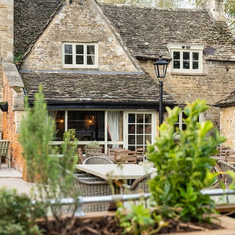
Food scene
Local pub and restaurant in South Cerney (good walk or short drive from site).
15 íbúar mæla með
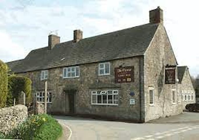
The Old George Inn
Local pub and restaurant in South Cerney (good walk or short drive from site).
Relish at The Gateway Cafe
17 Spine Rd ELakeside daytime Café (across the road from site).
Fresh wood-fired Pizzas for collection/delivery (across the road from site). With covered/heated outdoor dining area and bar available.
12 íbúar mæla með

Pizzeria 720
Spine Road EastFresh wood-fired Pizzas for collection/delivery (across the road from site). With covered/heated outdoor dining area and bar available.
The Old Boathouse
Local lakeside Bar & Restaurant (across the road from site).
Local lakeside bar & dining (short drive or about 15 min walk from site). Also home to Lakeside Ski, Board and Inflatable rides.
40 íbúar mæla með
The Lakeside Brasserie
Station RoadLocal lakeside bar & dining (short drive or about 15 min walk from site). Also home to Lakeside Ski, Board and Inflatable rides.
Local lakeside Café for breakfast/lunch (about 20-25 min walk from site).
24 íbúar mæla með
Waterside Cafe
Wickwater LaneLocal lakeside Café for breakfast/lunch (about 20-25 min walk from site).
Local daytime Café for breakfast/lunch/snacks with the added attraction of alpacas in residence!! A good 35-40 min walk or short drive from site.
8 íbúar mæla með
Jennies Kitchen
Fridays Ham LaneLocal daytime Café for breakfast/lunch/snacks with the added attraction of alpacas in residence!! A good 35-40 min walk or short drive from site.
Local daytime Café with lovely views @ the lake next door to Windrush Lake site. Also home to South Cerney Outdoor watersport equipment hire.
The Lodge at Lake 12
12 Spine Rd ELocal daytime Café with lovely views @ the lake next door to Windrush Lake site. Also home to South Cerney Outdoor watersport equipment hire.
Local takeaway/delivery or eat-in (not licensed bring your own, no corkage charge). A good walk or short drive from site.
6 íbúar mæla með
South Cerney Tandoori Balti House
7 Clarks HayLocal takeaway/delivery or eat-in (not licensed bring your own, no corkage charge). A good walk or short drive from site.
Everyone's favorite local chippy. A good walk or short drive from site.
15 íbúar mæla með
South Cerney Fish and Chips
Everyone's favorite local chippy. A good walk or short drive from site.
Igloo Restaurant - Cirencester
37 Castle StInternational/British cuisine in Cirencester.
Côte Brasserie - Cirencester
4 Black Jack StFrench cuisine in Cirencester
Indian Rasoi
14 Dollar StIndian, Asian, Balti restaurant (with takeaway) in Cirencester
Thai Emerald
36 Castle StThai, Asian restaurant (with takeaway) in Cirencester
Jicsaw Thai Restaurant
32 High StThai restaurant (with takeaway) in Cricklade
Chutney Indian Takeaway
90 High StIndian takeaway in Cricklade
The Cricklade Club
38 High StCafé, Brew Pub, Bar in Cricklade
Masons Arms
28 High StPub and restaurant in Meysey Hampton (short drive from site).
The Greyhound
Ashton RoadPub and restaurant in Siddington (short drive from site).
The Falcon Inn
London RoadPub and restaurant in Poulton (short drive from site).
The White Hart Inn
High RoadPub and restaurant in Ashton Keynes (short drive from site).
The Bakers Arms
Pub and restaurant in Somerford Keynes (short drive from site).
Piazza Fontana
30a Castle StItalian restaurant in Cirencester.
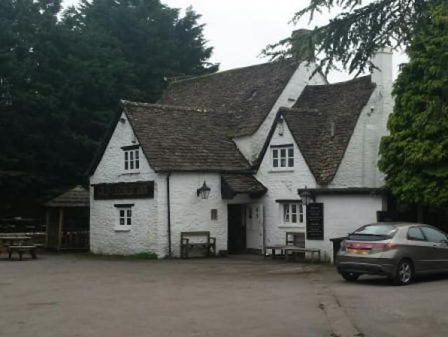
Pub and restaurant in Cerney Wick (short drive or good walk from site). Under new management and recently refurbished.
39 íbúar mæla með
The Crown Inn
63 Bristol RdPub and restaurant in Cerney Wick (short drive or good walk from site). Under new management and recently refurbished.
The Bell, Purton
Pub and restaurant in Purton Stoke (slightly longer drive from site)
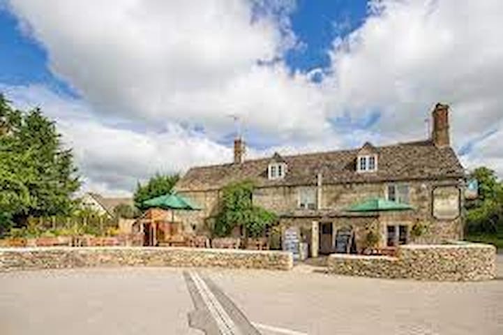
Local pub and restaurant in South Cerney (good walk or short drive from site).
15 íbúar mæla með
Eliot Arms
Local pub and restaurant in South Cerney (good walk or short drive from site).
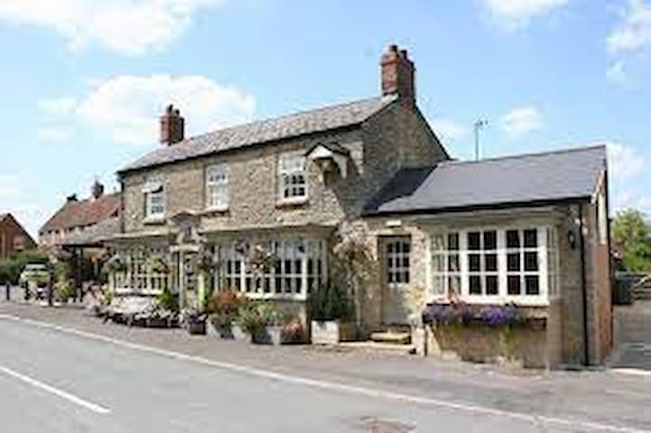
Local pub and restaurant in South Cerney (good walk or short drive from site)
22 íbúar mæla með
Royal Oak
High StreetLocal pub and restaurant in South Cerney (good walk or short drive from site)
Jambo Grill
Kenyan/African Grill in Cricklade (short drive from site)
Kavali (Cricklade)
Indian Restaurant and Takeaway in Cricklade (short drive from site)
Anglo-Indian Fusion Pub hosting Asha Indian Kitchen (good walk or short drive from site)
The Crown @ Cerney Wick
Anglo-Indian Fusion Pub hosting Asha Indian Kitchen (good walk or short drive from site)
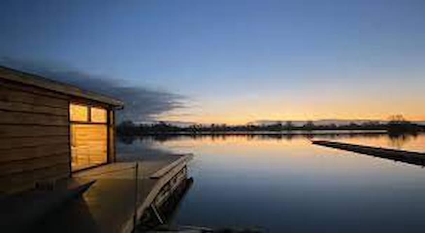
Watersport activities
Paddleboard, Kayak, Canoe, Sailing Boat or Windsurf Hire (or bring your own) @ the lake next door (home of The Lodge Café)
35 íbúar mæla með
South Cerney Outdoor
12 Spine Rd EPaddleboard, Kayak, Canoe, Sailing Boat or Windsurf Hire (or bring your own) @ the lake next door (home of The Lodge Café)
Paddleboard, Kayak (tandem/single) or Raft hire (or bring your own) across the road (next to the Gateway Centre). Open water swimming venue.
34 íbúar mæla með
Cotswold Water Park Hire
Spine Road EastPaddleboard, Kayak (tandem/single) or Raft hire (or bring your own) across the road (next to the Gateway Centre). Open water swimming venue.
Waterski, Wakeboards and Inflatable rides (about 15 mins walk) -also home to the Lakeside Brasserie
18 íbúar mæla með
Lakeside Ski & Wake
Station RoadWaterski, Wakeboards and Inflatable rides (about 15 mins walk) -also home to the Lakeside Brasserie
Whether enjoying a picnic or BBQ with friends and family on a sandy beach beside a beautiful swimming lagoon, or enjoying activities from water sports to mini golf or high ropes within beautiful parkland, the Cotswold Country Park and Beach offers the perfect day out.
88 íbúar mæla með
Cotswold Country Park & Beach
Spratsgate LaneWhether enjoying a picnic or BBQ with friends and family on a sandy beach beside a beautiful swimming lagoon, or enjoying activities from water sports to mini golf or high ropes within beautiful parkland, the Cotswold Country Park and Beach offers the perfect day out.
Waterskiing, wakeboarding, wake surfing, paddle boarding, inflatables and more for families, all ages and levels welcome.
9 íbúar mæla með
4 Lakes Waterski School
Waterskiing, wakeboarding, wake surfing, paddle boarding, inflatables and more for families, all ages and levels welcome.
Activities include Open Water Swimmimg, Stand Up Paddleboarding (SUP), Sailing, Windsurfing, Kayaking, Canoeing, Archery and Raft Building
12 íbúar mæla með
Waterland Outdoor Pursuits
Spratsgate LaneActivities include Open Water Swimmimg, Stand Up Paddleboarding (SUP), Sailing, Windsurfing, Kayaking, Canoeing, Archery and Raft Building
PADDLEBOARD & KAYAK HIRE DELIVERED TO YOUR DOOR
FAMILY RUN FOR FAMILY FUN...!!
We deliver our Kayaks and Paddleboards directly to your door if you are staying in lakeside Holiday lodges in South Cerney.
Paddleboarding, or SUP (Stand Up Paddleboarding) as it’s known, is the fastest growing watersport on the planet. The Cotswold Water Park and surrounding areas have proved a superb place to do this.
Cotswold Paddleboard Company
PADDLEBOARD & KAYAK HIRE DELIVERED TO YOUR DOOR
FAMILY RUN FOR FAMILY FUN...!!
We deliver our Kayaks and Paddleboards directly to your door if you are staying in lakeside Holiday lodges in South Cerney.
Paddleboarding, or SUP (Stand Up Paddleboarding) as it’s known, is the fastest growing watersport on the planet. The Cotswold Water Park and surrounding areas have proved a superb place to do this.
OPENS THURSDAY MAY 16 2024.
Beautiful outdoor swimming pool in Cirencester (10-15 mins drive from site).
45 íbúar mæla með
Cirencester Open Air Swimming Pool
OPENS THURSDAY MAY 16 2024.
Beautiful outdoor swimming pool in Cirencester (10-15 mins drive from site).
Indoor swimming at the Cricklade Leisure Centre pool (10-15 mins drive from site)
Cricklade Leisure Centre
6 Stones LnIndoor swimming at the Cricklade Leisure Centre pool (10-15 mins drive from site)
Indoor swimming in the pool at the Cotswold Leisure Centre (10-15 mins drive from site)
Cotswold Leisure - Cirencester
Tetbury RoadIndoor swimming in the pool at the Cotswold Leisure Centre (10-15 mins drive from site)
Cycle Hire
Performance Cycles
Spine Road EastLocal cycle hire and cafe. Station Road junction of the Spine Road.
Walks
URL for Cotswold Water Park Visitors Guide:
https://waterpark.org
Lots of info but see particularly 'Things to Do' tab for maps of local walks, running trails and cycle routes.
126 íbúar mæla með
Cotswold Water Park
Rigsby's LaneURL for Cotswold Water Park Visitors Guide:
https://waterpark.org
Lots of info but see particularly 'Things to Do' tab for maps of local walks, running trails and cycle routes.
URL for map of Cirencester Park trails: https://www.bathurstestate.co.uk/visitors/cirencester-park/
7 íbúar mæla með
The Bathurst Estate & Cirencester Park
Park StreetURL for map of Cirencester Park trails: https://www.bathurstestate.co.uk/visitors/cirencester-park/
Home to 2,500 different species from the far corners of the globe and 5 national tree collections, Westonbirt is the perfect place for you to escape, relax or have an adventure! Take a journey up into the canopy on the STIHL Tree Top Walkway, stop by the café for a tasty treat or see if you can spot the Gruffalo!
340 íbúar mæla með
Westonbirt, Þjóðartrégarðurinn
Home to 2,500 different species from the far corners of the globe and 5 national tree collections, Westonbirt is the perfect place for you to escape, relax or have an adventure! Take a journey up into the canopy on the STIHL Tree Top Walkway, stop by the café for a tasty treat or see if you can spot the Gruffalo!
Other Activities
Combat Splat Paintball
Spine Road EastThe Cotswold Range
Archery, Crossbow & Air Rifles
Experience the ultimate adrenaline rush with rally and off-road driving. Ages 10+ no experience necessary.
Cotswold Off Road
Cirencester RoadExperience the ultimate adrenaline rush with rally and off-road driving. Ages 10+ no experience necessary.
The Tackle Den
23 Wickwater LaneFishing tacle shop for all your fishing needs.
Contemporary and abstract sculptures set in a tranquil woodland with ponds, gardens, glades, tea-room and free parking.
18 íbúar mæla með
Cotswold Sculpture Park
Summerford KeymsContemporary and abstract sculptures set in a tranquil woodland with ponds, gardens, glades, tea-room and free parking.
Old Downs Pursuits
Archery, clay target and air-rifle shooting. No experience necessary.
BHS riding centre open 7 days a week. Group or individual lessons, minimum age 4.
Rein & Shine Equestrian Centre
1 Braydon RoadBHS riding centre open 7 days a week. Group or individual lessons, minimum age 4.
18 hole parkland course with indoor and outdoor driving range, putting green, café and bar. Visitors welcome.
14 íbúar mæla með
South Cerney Golf Club
Northmoor Lane18 hole parkland course with indoor and outdoor driving range, putting green, café and bar. Visitors welcome.
Rare Breeds Visitor Center, Farm Shop and Tea Room
13 íbúar mæla með
The Butts Farm Rare Breeds, Farm Shop and Tea Room
Cricklade RoadRare Breeds Visitor Center, Farm Shop and Tea Room
Little Centurions is a state of the art, Roman-themed, indoor soft play centre located in Cirencester, the capital of the Cotswolds. Our high-quality, modern facility opened in 2021 to entertain and engage young children up to 10 years, but aimed towards little ones.
Little Centurions Soft Play
Little Centurions is a state of the art, Roman-themed, indoor soft play centre located in Cirencester, the capital of the Cotswolds. Our high-quality, modern facility opened in 2021 to entertain and engage young children up to 10 years, but aimed towards little ones.
The Cirencester inside play park has a variety of different play areas and entertainment for your kids to get stuck in while you can enjoy our onsite cafe.
7 íbúar mæla með
Rugrats and Half Pints Cirencester
Unit A Meadow RdThe Cirencester inside play park has a variety of different play areas and entertainment for your kids to get stuck in while you can enjoy our onsite cafe.
Home of Adam Henson!! Ready to explore, play, eat, feed and learn? Meet 50+ rare breeds of British farm animals, whizz along our zipline, hold little chicks and pedal on our tractors, all in a day at Cotswold Farm Park!
251 íbúar mæla með
Cotswold Farm Park
Home of Adam Henson!! Ready to explore, play, eat, feed and learn? Meet 50+ rare breeds of British farm animals, whizz along our zipline, hold little chicks and pedal on our tractors, all in a day at Cotswold Farm Park!
Discover an amazing world of birds and their Jurassic ancestors on your day out in the Cotswolds
Birdland Park & Gardens
Discover an amazing world of birds and their Jurassic ancestors on your day out in the Cotswolds
The Cotswold Wildlife Park & Gardens exhibits over 260 different species of animals. The park is set in 160 acres of landscaped parkland and gardens 2 miles south of Burford, on the A361, Oxfordshire, England.
442 íbúar mæla með
Cotswold Villtafuglaparkur og garðar
The Cotswold Wildlife Park & Gardens exhibits over 260 different species of animals. The park is set in 160 acres of landscaped parkland and gardens 2 miles south of Burford, on the A361, Oxfordshire, England.
The Corinium Museum, in the Cotswold town of Cirencester in England, has a large collection of objects found in and around the locality. The bulk of the exhibits are from the Roman town of Corinium Dobunnorum, but the museum includes material from as early as the Neolithic and all the way up to Victorian times.
80 íbúar mæla með
Corinium Museum
Park StreetThe Corinium Museum, in the Cotswold town of Cirencester in England, has a large collection of objects found in and around the locality. The bulk of the exhibits are from the Roman town of Corinium Dobunnorum, but the museum includes material from as early as the Neolithic and all the way up to Victorian times.