
Guidebook for Praia da Vitória
Food Scene
Restaurante La Barca
Nome Actual: Gotas Flutuantes
Actual name: Gotas Flutuantes
Restaurante 'Xisa-Mar' De Aguiar & Fagundes, Lda.
Nome Actual: Gotas Flutuantes
Actual name: Gotas Flutuantes
Terezinha Café
Rua de JesusCervejaria Santa Cruz - Ligia Maria Evangelho Costa Rocha
Rua de JesusRestaurante O Pescador
11 R. Conselheiro José CardosoRestaurante Ti Choa
Caneta
q.b. - Food Court
50 Caminho do Meio de São CarlosAdega de São Mateus
Largo do Padre Manuel Maria da CostaJoão H Melo Cota
5 Canada do PilarQueijo Vaquina - Fabrica de queijo onde se pode degustar as suas aravilhas
Shopping
Loja Expert (Electrodomesticos/appliances)
Cabeleireiro/Hairdresser
Manicure/Manicure
Roupa/clothes
Pastelaria/Pastery
Decoração/Decorative itens
Acessórios de moda/Acessories
7 íbúar mæla með
Fórum Terceira
Avenida Paço do MilhafreLoja Expert (Electrodomesticos/appliances)
Cabeleireiro/Hairdresser
Manicure/Manicure
Roupa/clothes
Pastelaria/Pastery
Decoração/Decorative itens
Acessórios de moda/Acessories
Continente Modelo Praia da Vitória
Estrada da CircunvalaçãoOurivesaria Pimentel
18 B R. de JesusOuriversaria/jewelery
Artigos de pesca
Artigos de limpeza
Artigos de campismo
Artigos de animais
etc.
---
Fishing items
Cleaning articles
Camping goods
Articles of animals
etc.
Equipraia, Lda.
31/33 R. Cidade ArtesiaArtigos de pesca
Artigos de limpeza
Artigos de campismo
Artigos de animais
etc.
---
Fishing items
Cleaning articles
Camping goods
Articles of animals
etc.
Marina Souvenirs
19-3 Poço da AreiaFórum Terceira
Avenida Paço do MilhafreEspaço calmo e acolhedor para fazer compras
Essentials
Farmácia Silva
26 Largo Conde Praia da VitóriaFarmácia/pharmacy
Lavandaria Artesia Lda.
Church of Santa Cruz
1761 P. Francisco Ornelas da Câmara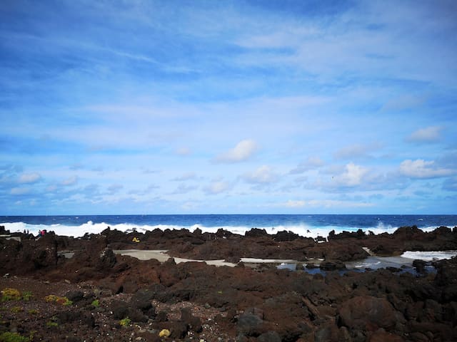
Piscinas Naturais Dos Biscoitos
Entertainment & Activities
Praia Cultural Coop De Interesse Publico E De Responsabilidade Lda.
64 Rua Serpa PintoOctopus Diving Center
Rope Adventures
Avenida da Beira-MarTerceira Island Golf Club
Drinks & Nightlife
Blues Bar
Avenida Álvaro Martins HomemParks & Nature
A península do Monte Brasil localiza-se na freguesia da Sé, na cidade e concelho de Angra do Heroísmo, na costa sul da ilha Terceira, nos Açores.
Constitui-se no cone abatido de um antigo vulcão extinto, com origem no mar, composto por uma caldeira rodeada por quatro picos: o Pico das Cruzinhas, o Pico do Facho, o Pico da Quebrada (onde se situa a vigia da baleia) e o Pico do Zimbreiro. Mantém restos da cobertura vegetal original e encontra-se classificada como Reserva Florestal de Recreio.
Forma duas baías: a baía de Angra, a Leste, que deu o nome à cidade, e a baía do Fanal, a Oeste.
De seu alto descortina-se uma vista panorâmica sobre a cidade, sua baía e marina, o Porto Judeu, a Ribeirinha, os Ilhéus e, para Poente, desde a baía do Fanal, passando pela baía de Villa Maria até à freguesia São Mateus da Calheta. Do seu topo, em dias limpos pode ver-se, para o Poente, a ilha de São Jorge e a ilha do Pico, a freguesia piscatória de São Mateus da Calheta; o Caminho de Baixo, a localidade de São Carlos, a zona balnear da Silveira e toda a cidade de Angra. A Este, subindo a Serra da Ribeirinha, vê-se a freguesia do mesmo nome, mais abaixo, junto ao mar o Porto Judeu surge, juntamente com a vista dos Ilhéus das Cabras. Olhando para o interior, descortina-se a maior elevação da ilha, a serra de Santa Bárbara, ao lado da Serra do Morião ou da Nasce Água.
Entre o final do século XVI e o início do XVII, foi quase que inteiramente rodeada pelos espanhóis por uma das maiores fortificações atlânticas da época: a Fortaleza de São João Baptista. Era ela que, juntamente com o Forte de São Sebastião, defendia a cidade e o porto de Angra dos ataques dos piratas e corsários que tentavam apoderar-se das riquezas trazidas pelas naus da Carreira da Índia.
No Monte Brasil existem outros locais de referência como é o caso da Ermida de Santo António, erguida em 1615.
__
The peninsula of Monte Brazil is located in the parish of the Cathedral in the city and Angra do Heroísmo municipality, on the south coast of the island of Terceira in the Azores.
Constitutes the cone shot of an ancient extinct volcano, originating from the sea, consisting of a boiler surrounded by four peaks: Peak of the Crosses, Pico do Facho, Pico da Quebrada (where is the lookout whale) and Pico Zimbreiro. Keeps remains of the original vegetation cover and is classified as Recreational Forest Reserve.
Form two bays: the bay of Angra in the east, which gave the name to the city and the Bay of Fanal, the West.
From the top opens up to a panoramic view of the city, the bay and marina, the Jewish Porto, the riverfront, the Islanders, and to West, from the bay of Fanal, through the bay of Villa Maria to St. Matthew parish of calheta. From the top, on clear days can be seen to the west, the island of São Jorge and Pico, the fishing village of São Mateus da Calheta; Down the path, the town of San Carlos, the bathing area of Silveira and the entire city of Angra. A This, climbing the Serra da Ribeirinha, see the parish of the same name, below, by the sea the Jewish Port comes along with the view of Cabras Islets. Looking inland, gurgling is the highest elevation of the island, the mountains of Santa Barbara, next to the Serra do the Morião or water born.
Between the end of the sixteenth century and early seventeenth centuries, it was almost entirely surrounded by the Spanish one of the largest Atlantic fortifications of the time: the Fortress of St. John the Baptist. It was she who, along with the Fort of São Sebastião, defended the city and port of Angra dos attacks of pirates and privateers who tried to seize the wealth brought by the ships of India's career.
At Monte Brazil there are other landmarks such as the St. Anthony's Chapel, built in 1615.
https://pt.wikipedia.org/wiki/Monte_Brasil
39 íbúar mæla með
Monte Brasil
Monte Brasil A península do Monte Brasil localiza-se na freguesia da Sé, na cidade e concelho de Angra do Heroísmo, na costa sul da ilha Terceira, nos Açores.
Constitui-se no cone abatido de um antigo vulcão extinto, com origem no mar, composto por uma caldeira rodeada por quatro picos: o Pico das Cruzinhas, o Pico do Facho, o Pico da Quebrada (onde se situa a vigia da baleia) e o Pico do Zimbreiro. Mantém restos da cobertura vegetal original e encontra-se classificada como Reserva Florestal de Recreio.
Forma duas baías: a baía de Angra, a Leste, que deu o nome à cidade, e a baía do Fanal, a Oeste.
De seu alto descortina-se uma vista panorâmica sobre a cidade, sua baía e marina, o Porto Judeu, a Ribeirinha, os Ilhéus e, para Poente, desde a baía do Fanal, passando pela baía de Villa Maria até à freguesia São Mateus da Calheta. Do seu topo, em dias limpos pode ver-se, para o Poente, a ilha de São Jorge e a ilha do Pico, a freguesia piscatória de São Mateus da Calheta; o Caminho de Baixo, a localidade de São Carlos, a zona balnear da Silveira e toda a cidade de Angra. A Este, subindo a Serra da Ribeirinha, vê-se a freguesia do mesmo nome, mais abaixo, junto ao mar o Porto Judeu surge, juntamente com a vista dos Ilhéus das Cabras. Olhando para o interior, descortina-se a maior elevação da ilha, a serra de Santa Bárbara, ao lado da Serra do Morião ou da Nasce Água.
Entre o final do século XVI e o início do XVII, foi quase que inteiramente rodeada pelos espanhóis por uma das maiores fortificações atlânticas da época: a Fortaleza de São João Baptista. Era ela que, juntamente com o Forte de São Sebastião, defendia a cidade e o porto de Angra dos ataques dos piratas e corsários que tentavam apoderar-se das riquezas trazidas pelas naus da Carreira da Índia.
No Monte Brasil existem outros locais de referência como é o caso da Ermida de Santo António, erguida em 1615.
__
The peninsula of Monte Brazil is located in the parish of the Cathedral in the city and Angra do Heroísmo municipality, on the south coast of the island of Terceira in the Azores.
Constitutes the cone shot of an ancient extinct volcano, originating from the sea, consisting of a boiler surrounded by four peaks: Peak of the Crosses, Pico do Facho, Pico da Quebrada (where is the lookout whale) and Pico Zimbreiro. Keeps remains of the original vegetation cover and is classified as Recreational Forest Reserve.
Form two bays: the bay of Angra in the east, which gave the name to the city and the Bay of Fanal, the West.
From the top opens up to a panoramic view of the city, the bay and marina, the Jewish Porto, the riverfront, the Islanders, and to West, from the bay of Fanal, through the bay of Villa Maria to St. Matthew parish of calheta. From the top, on clear days can be seen to the west, the island of São Jorge and Pico, the fishing village of São Mateus da Calheta; Down the path, the town of San Carlos, the bathing area of Silveira and the entire city of Angra. A This, climbing the Serra da Ribeirinha, see the parish of the same name, below, by the sea the Jewish Port comes along with the view of Cabras Islets. Looking inland, gurgling is the highest elevation of the island, the mountains of Santa Barbara, next to the Serra do the Morião or water born.
Between the end of the sixteenth century and early seventeenth centuries, it was almost entirely surrounded by the Spanish one of the largest Atlantic fortifications of the time: the Fortress of St. John the Baptist. It was she who, along with the Fort of São Sebastião, defended the city and port of Angra dos attacks of pirates and privateers who tried to seize the wealth brought by the ships of India's career.
At Monte Brazil there are other landmarks such as the St. Anthony's Chapel, built in 1615.
https://pt.wikipedia.org/wiki/Monte_Brasil
O único vulcão visitável do mundo fica nos Açores - Ilha Terceira
O cone vulcânico, que alberga no seu interior o Algar do Carvão, situa-se sensivelmente no meio da ilha Terceira, a norte da cidade de Angra do Heroísmo, distando desta cerca de 12 Km por estrada. O acesso é fácil, recorrendo à rede viária pública que apresenta sinalização suficiente para o efeito. Possui uma posição geográfica de coordenadas 38°43'41.54"N 27°12'59.01"W e uma altitude de sensivelmente 640 m
___
The only visitable volcano in the world is in the Azores - Terceira Island
The volcanic cone, which houses inside the Algar Coal, is located roughly in the middle of the Island, north of the city of Angra do Heroísmo, lying about 12 km of this road. Access is easy, using the public road network that has sufficient signal for this purpose. It has a geographical position coordinates 38 ° 43'41.54 "N 27 ° 12'59.01" W and an altitude of roughly 640 m
http://www.montanheiros.com/algarCarvao/
44 íbúar mæla með
Algar do Carvão - Regional Natural Monument
O único vulcão visitável do mundo fica nos Açores - Ilha Terceira
O cone vulcânico, que alberga no seu interior o Algar do Carvão, situa-se sensivelmente no meio da ilha Terceira, a norte da cidade de Angra do Heroísmo, distando desta cerca de 12 Km por estrada. O acesso é fácil, recorrendo à rede viária pública que apresenta sinalização suficiente para o efeito. Possui uma posição geográfica de coordenadas 38°43'41.54"N 27°12'59.01"W e uma altitude de sensivelmente 640 m
___
The only visitable volcano in the world is in the Azores - Terceira Island
The volcanic cone, which houses inside the Algar Coal, is located roughly in the middle of the Island, north of the city of Angra do Heroísmo, lying about 12 km of this road. Access is easy, using the public road network that has sufficient signal for this purpose. It has a geographical position coordinates 38 ° 43'41.54 "N 27 ° 12'59.01" W and an altitude of roughly 640 m
http://www.montanheiros.com/algarCarvao/
Após 25 de Dezembro de 1969, com a celebração pelo Patriarca das Índias D. José Vieira Alvernaz, passou a chamar-se de Gruta do Natal. Esta data marca ainda a abertura da gruta pela primeira vez à população, para tal tendo sido construído um acesso simples e instalada uma iluminação rudimentar.
Têm sido realizadas, noutros anos, a Missa de Natal, tendo a gruta sido já palco também de um baptizado e de um casamento.
After December 25, 1969, with the celebration of the Patriarch of the Indies José Vieira Alvernaz, he came to be called Christmas Cave. This date also marks the opening of the cave for the first time to the public, for such has been built and installed a simple access a rudimentary lighting.
Have been held in other years, the Christmas Mass, with the cave have also been the stage of a christening and a wedding.
http://www.montanheiros.com/grutaNatal/
22 íbúar mæla með
Gruta Natal
Após 25 de Dezembro de 1969, com a celebração pelo Patriarca das Índias D. José Vieira Alvernaz, passou a chamar-se de Gruta do Natal. Esta data marca ainda a abertura da gruta pela primeira vez à população, para tal tendo sido construído um acesso simples e instalada uma iluminação rudimentar.
Têm sido realizadas, noutros anos, a Missa de Natal, tendo a gruta sido já palco também de um baptizado e de um casamento.
After December 25, 1969, with the celebration of the Patriarch of the Indies José Vieira Alvernaz, he came to be called Christmas Cave. This date also marks the opening of the cave for the first time to the public, for such has been built and installed a simple access a rudimentary lighting.
Have been held in other years, the Christmas Mass, with the cave have also been the stage of a christening and a wedding.
http://www.montanheiros.com/grutaNatal/
As Furnas do Enxofre situam-se no concelho de Praia da Vitória, bem no coração da magnífica Ilha Terceira, Arquipélago dos Açores.
Classificadas como Monumento Natural Regional, nas Furnas do Enxofre podem ser observadas fumarolas, vestígios mais visíveis da última erupção vulcânica ocorrida na ilha Terceira, no século XVIII.
O vulcão, serenado, ainda apresenta actividade através destas fumarolas, que emitem gases quentes e vapor odorífero, através de um sistema de fissuras ao redor das quais se formam depósitos de enxofre, em resultado da infiltração das chuvas nestas.
O local é, igualmente, habitat para interessantes espécies vegetais naturais de zonas com estas características geológicas, com um micro-clima próprio, parte dos sítios de importância comunitária para a região biogeográfica macaronésica.
___
Furnas Sulphur are located in Praia da Vitoria municipality, right in the heart of the wonderful Terceira Island, Azores Archipelago.
Classified as Regional Natural Monument, in Sulphur Furnas fumaroles can be observed, most visible remains of the last volcanic eruption on the island of Terceira in the eighteenth century.
The volcano, pacified also exhibits activity through these fumarole and emitting hot gases and odorous vapor through a system of cracks around which deposits of sulfur are formed as a result of infiltration of rain these.
The place is also habitat for plant species interesting natural areas with these geological features with a micro-climate itself, part of sites of Community importance for the Macaronesian biogeographical region.
https://www.guiadacidade.pt/pt/poi-furnas-do-enxofre-ilha-terceira-18612
20 íbúar mæla með
Furnas do Enxofre
As Furnas do Enxofre situam-se no concelho de Praia da Vitória, bem no coração da magnífica Ilha Terceira, Arquipélago dos Açores.
Classificadas como Monumento Natural Regional, nas Furnas do Enxofre podem ser observadas fumarolas, vestígios mais visíveis da última erupção vulcânica ocorrida na ilha Terceira, no século XVIII.
O vulcão, serenado, ainda apresenta actividade através destas fumarolas, que emitem gases quentes e vapor odorífero, através de um sistema de fissuras ao redor das quais se formam depósitos de enxofre, em resultado da infiltração das chuvas nestas.
O local é, igualmente, habitat para interessantes espécies vegetais naturais de zonas com estas características geológicas, com um micro-clima próprio, parte dos sítios de importância comunitária para a região biogeográfica macaronésica.
___
Furnas Sulphur are located in Praia da Vitoria municipality, right in the heart of the wonderful Terceira Island, Azores Archipelago.
Classified as Regional Natural Monument, in Sulphur Furnas fumaroles can be observed, most visible remains of the last volcanic eruption on the island of Terceira in the eighteenth century.
The volcano, pacified also exhibits activity through these fumarole and emitting hot gases and odorous vapor through a system of cracks around which deposits of sulfur are formed as a result of infiltration of rain these.
The place is also habitat for plant species interesting natural areas with these geological features with a micro-climate itself, part of sites of Community importance for the Macaronesian biogeographical region.
https://www.guiadacidade.pt/pt/poi-furnas-do-enxofre-ilha-terceira-18612
Reserva Florestal de Recreio da Lagoa das Patas
Reserva Florestal de Recreio da Serreta
M1044Relvao Borgarhlið
Algar do Carvão - Regional Natural Monument
Gruta Natal
Reserva Florestal Parcial da Serra de S. Barbara e dos Misterios Negros
Lagoa do Negro
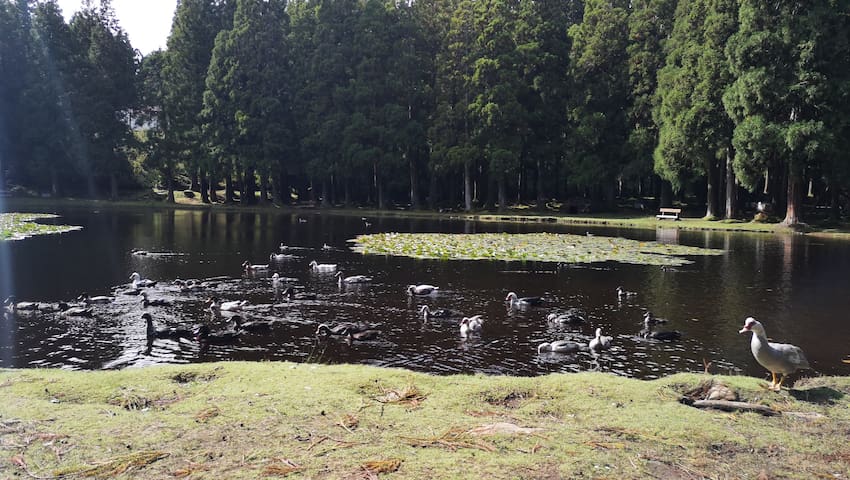
Lagoa das Patas vatn
Sightseeing
Reserva Florestal Parcial da Serra de S. Barbara e dos Misterios Negros
Serra do Cume
Serra de Santa Bárbara
Farol Das Contendas
M509