
Explore Cape Breton!
Favorite Destination
The fortress and town were partially reconstructed in the 1960s and 1970s, using some of the original stonework, which provided jobs for unemployed coal miners. The site is operated by Parks Canada as a living history museum. The site stands as the largest reconstruction project in North America.
24 íbúar mæla með
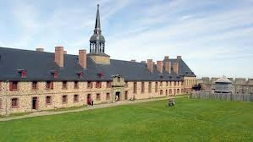
Fortress Of Louisbourg
The fortress and town were partially reconstructed in the 1960s and 1970s, using some of the original stonework, which provided jobs for unemployed coal miners. The site is operated by Parks Canada as a living history museum. The site stands as the largest reconstruction project in North America.
Alexander Graham Bell National Historic Site commemorates the genius and compassion of renowned inventor Alexander Graham Bell. Exhibits show how he and his associates achieved Canada’s first powered flight with their airplane Silver Dart, produced the world’s fastest boat, advanced recording technology, designed giant kites and, of course, invented the telephone. Original artefacts, films, and family photographs highlight his scientific and humanitarian work. Visitors can also enjoy hands-on activities and a variety of programs. Situated on 10 hectares of land with a superb view of the Bras d’Or Lake in Baddeck on Cape Breton Island, the Site overlooks Bell’s summer home, Beinn Bhreagh, still privately owned by his descendants.
63 íbúar mæla með
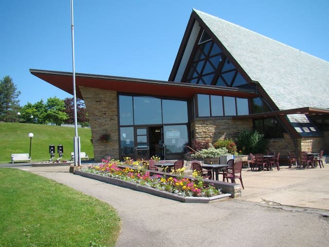
Alexander Graham Bell National Historic Site
559 Chebucto StAlexander Graham Bell National Historic Site commemorates the genius and compassion of renowned inventor Alexander Graham Bell. Exhibits show how he and his associates achieved Canada’s first powered flight with their airplane Silver Dart, produced the world’s fastest boat, advanced recording technology, designed giant kites and, of course, invented the telephone. Original artefacts, films, and family photographs highlight his scientific and humanitarian work. Visitors can also enjoy hands-on activities and a variety of programs. Situated on 10 hectares of land with a superb view of the Bras d’Or Lake in Baddeck on Cape Breton Island, the Site overlooks Bell’s summer home, Beinn Bhreagh, still privately owned by his descendants.
Situated on one of the most picturesque coasts of Cape Breton Island, on a 15-acre site filled with wild roses and grasses, the Cape Breton Miners Museum pays tribute to the region's long and rich history of coal mining. It is home to profound stories of miners and their families, and the resource that helped build a nation. The Museum is also home to the famous choir of miners – The Men of the Deeps. Plan a visit to the Museum where you can join a retired mine guide for an underground mine tour, browse the modern exhibits and stroll through our historic village. Complete your visit with a delicious home cooked meal at the Miners Village Restaurant.
46 íbúar mæla með
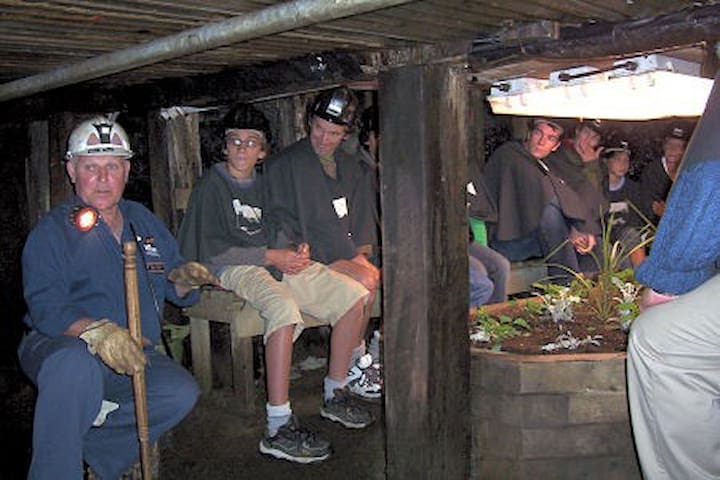
Miner's Museum
17 Museum StSituated on one of the most picturesque coasts of Cape Breton Island, on a 15-acre site filled with wild roses and grasses, the Cape Breton Miners Museum pays tribute to the region's long and rich history of coal mining. It is home to profound stories of miners and their families, and the resource that helped build a nation. The Museum is also home to the famous choir of miners – The Men of the Deeps. Plan a visit to the Museum where you can join a retired mine guide for an underground mine tour, browse the modern exhibits and stroll through our historic village. Complete your visit with a delicious home cooked meal at the Miners Village Restaurant.
In a world of nanosecond speeds and cloud technology, it’s hard to remember a time when wireless messages couldn’t even cross the Atlantic. Guglielmo Marconi would change the world forever with the first official transatlantic exchange of radio messages at Glace Bay. Find out how Marconi triumphed at his first permanent transatlantic wireless station at Table Head, and how his work would usher in the age of global communications.
Marconi National Historic Site
15 Timmerman StIn a world of nanosecond speeds and cloud technology, it’s hard to remember a time when wireless messages couldn’t even cross the Atlantic. Guglielmo Marconi would change the world forever with the first official transatlantic exchange of radio messages at Glace Bay. Find out how Marconi triumphed at his first permanent transatlantic wireless station at Table Head, and how his work would usher in the age of global communications.
Meat Cove is the most northerly settlement in Nova Scotia and is located in Northern Cape Breton. It's accessed north of Capstick on 8 km of a gravel road. It has a wonderful seafood restaurant at the Meat Cove Campground and Chowder House. The rugged picturesque landscape makes for a beautiful backdrop during a camping trip, or day excursion to explore the area. Meat cove has pristine ocean water sporting 80-foot visibility through the water. The cove makes for a great swimming and snorkeling destination.
9 íbúar mæla með
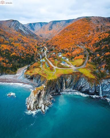
Meat Cove
Meat Cove is the most northerly settlement in Nova Scotia and is located in Northern Cape Breton. It's accessed north of Capstick on 8 km of a gravel road. It has a wonderful seafood restaurant at the Meat Cove Campground and Chowder House. The rugged picturesque landscape makes for a beautiful backdrop during a camping trip, or day excursion to explore the area. Meat cove has pristine ocean water sporting 80-foot visibility through the water. The cove makes for a great swimming and snorkeling destination.
Experience the natural beauty of the Cape Breton Highlands as you drive the famous Cabot Trail. This 298 km (186 mi) highway weaves through The Cape Breton Highlands National Park, rewarding travellers with spectacular valley and coastal views all along the way.
Looking for more ways to explore? Hike and camp within the Cape Breton Highlands National Park, play a round of golf at Highlands Links, peruse artisan shops along the trail, or book your spot on a sea kayaking, cycling, or whale watching tour. In the winter months, downhill skiing, cross-country skiing, winter hiking, snowmobiling and more will continue to bring you back to experience adventures around the Cabot Trail.
54 íbúar mæla með
Cabot Trail
Cabot TrailExperience the natural beauty of the Cape Breton Highlands as you drive the famous Cabot Trail. This 298 km (186 mi) highway weaves through The Cape Breton Highlands National Park, rewarding travellers with spectacular valley and coastal views all along the way.
Looking for more ways to explore? Hike and camp within the Cape Breton Highlands National Park, play a round of golf at Highlands Links, peruse artisan shops along the trail, or book your spot on a sea kayaking, cycling, or whale watching tour. In the winter months, downhill skiing, cross-country skiing, winter hiking, snowmobiling and more will continue to bring you back to experience adventures around the Cabot Trail.
Sightseeing
The Skyline Trail is an eight-kilometer, looping, hiking trail at Cape Breton Highlands National Park in Nova Scotia, Canada. It lies on the western side of the Cabot Trail, near French Mountain's summit. This trail is well known for its scenic views. The path to the boardwalk has stellar views.
There is also a longer hike loop that provides a variety of plant life and mountain views. Take some water with you. You might even encounter some wildlife. Around 2-3 hours but most of the time is better spent at the view of the skyline.
64 íbúar mæla með
Skyline Trail
The Skyline Trail is an eight-kilometer, looping, hiking trail at Cape Breton Highlands National Park in Nova Scotia, Canada. It lies on the western side of the Cabot Trail, near French Mountain's summit. This trail is well known for its scenic views. The path to the boardwalk has stellar views.
There is also a longer hike loop that provides a variety of plant life and mountain views. Take some water with you. You might even encounter some wildlife. Around 2-3 hours but most of the time is better spent at the view of the skyline.
Climb up and up to your reward at the top! Large flat rocks give you a nice place to sit and enjoy the 360-degree views of the entire Clyburn Brook canyon and the Atlantic coastline from Cape Smokey to Ingonish. Gaze back at the mountains, the sheer rocky face of Franey Mountain, or the river winding through the valley, 425 m below. Keep an eye out for wildlife - moose like this habitat too. Caution: Keep young children away from the steep cliffs.
Trailhead: Turn off the Cabot Trail just north of the Clyburn River and follow the fire access road for about 1 km to a small parking lot.
Significant Feature: Transition from Acadian to boreal forest; beautiful views
Length: 7.4 km (4.6 mi) loop
Hiking Time: 2–3 hours
Elevation: 95–430 m (310–1410 ft.)
Steep climb. Rugged sections.
Trail Rating: Difficult
GPS Co-ordinates for Trailhead (in decimal degrees):
Lat: 46.660766 Long: -60.422683
Open from mid-May to mid-October. A park pass is required for hiking or the use of the other services in the park. A park entry fee applies. Check-in at the Parks Canada visitor centres in Chéticamp (16 Visitor Centre Rd., situated on the west side of the park) or in Ingonish (37637 Cabot Trail, on the east side of the park) to obtain passes, information on visitor safety and any other information you may need, including a trail location map.
For your comfort and safety:
- Do not approach, disturb or feed wild animals.
- Take along appropriate clothing – rapid weather changes often occur on the plateau or along the coast.
- Carry water with you, especially for longer trails, climbs or open barrens.
- Bring insect repellent as black flies and mosquitoes are common all summer.
- Mountain bikes are permitted only where indicated, for public safety and protection of the environment.
- Stay on boardwalks to protect fragile vegetation.
- Do not throw food or scraps along the trails or roads.
- Read "Keep it Wild, Keep it Safe" brochure, available at park visitor centres and on the Parks Canada website.
10 íbúar mæla með

Franey Trail Head
49 Franey RdClimb up and up to your reward at the top! Large flat rocks give you a nice place to sit and enjoy the 360-degree views of the entire Clyburn Brook canyon and the Atlantic coastline from Cape Smokey to Ingonish. Gaze back at the mountains, the sheer rocky face of Franey Mountain, or the river winding through the valley, 425 m below. Keep an eye out for wildlife - moose like this habitat too. Caution: Keep young children away from the steep cliffs.
Trailhead: Turn off the Cabot Trail just north of the Clyburn River and follow the fire access road for about 1 km to a small parking lot.
Significant Feature: Transition from Acadian to boreal forest; beautiful views
Length: 7.4 km (4.6 mi) loop
Hiking Time: 2–3 hours
Elevation: 95–430 m (310–1410 ft.)
Steep climb. Rugged sections.
Trail Rating: Difficult
GPS Co-ordinates for Trailhead (in decimal degrees):
Lat: 46.660766 Long: -60.422683
Open from mid-May to mid-October. A park pass is required for hiking or the use of the other services in the park. A park entry fee applies. Check-in at the Parks Canada visitor centres in Chéticamp (16 Visitor Centre Rd., situated on the west side of the park) or in Ingonish (37637 Cabot Trail, on the east side of the park) to obtain passes, information on visitor safety and any other information you may need, including a trail location map.
For your comfort and safety:
- Do not approach, disturb or feed wild animals.
- Take along appropriate clothing – rapid weather changes often occur on the plateau or along the coast.
- Carry water with you, especially for longer trails, climbs or open barrens.
- Bring insect repellent as black flies and mosquitoes are common all summer.
- Mountain bikes are permitted only where indicated, for public safety and protection of the environment.
- Stay on boardwalks to protect fragile vegetation.
- Do not throw food or scraps along the trails or roads.
- Read "Keep it Wild, Keep it Safe" brochure, available at park visitor centres and on the Parks Canada website.
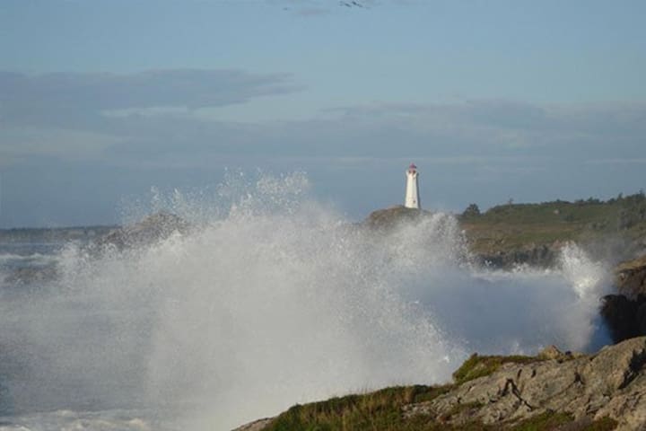
Enjoy an iconic coastal hiking experience at the Lighthouse Trail, located across the harbour from the Fortress of Louisbourg. Known for its spectacular crashing waves and unsurpassed ocean vistas, this trail is not to be missed. Capture an authentic East Coast moment in front of the Louisbourg Lighthouse, located at the trailhead. Families can explore the gentle, 2-kilometre (1.3-mile) looped trail, watching for shorebirds and fishing boats sailing into the harbour. Experienced hikers can follow the rugged shoreline beyond, where the Coastal Connections Trail Association continues to develop the trail.
Contributions made in the donation box at the trailhead directly support the Coastal Connections Trail Association in their efforts to continue the development of the trail. Donation boxes are also located throughout the community of Louisbourg.
To access the trail year-round, follow the "Lighthouse" signs along Havenside Road. The iconic lighthouse is on the site of the first lighthouse in Canada (1734). Interpretive panels share the history of this pivotal spot and highlight the rare plant life and coastal ecology of the area.
Travelling with a beloved pet? Dogs on leash are permitted on the Old Town Trail, the Lighthouse Trail, and at Kennington Cove Beach. Thank you for cleaning up after your pet. Pick up droppings and place them in appropriate refuse containers.
For your comfort and safety:
- Do not approach, disturb or feed wild animals.
- Take along appropriate clothing – rapid weather changes often occur along the coast.
- Carry water with you.
- Bring insect repellent as black flies and mosquitoes are common all summer.
- Mountain bikes are permitted only where indicated, for public safety and protection of the environment.
- Stay on boardwalks to protect fragile vegetation.
- Do not throw food or scraps along the trails or roads.
- Read "Keep it Wild, Keep it Safe" brochure, available on the Parks Canada website.
24 íbúar mæla með
Louisbourg Lighthouse
555 Havenside RdEnjoy an iconic coastal hiking experience at the Lighthouse Trail, located across the harbour from the Fortress of Louisbourg. Known for its spectacular crashing waves and unsurpassed ocean vistas, this trail is not to be missed. Capture an authentic East Coast moment in front of the Louisbourg Lighthouse, located at the trailhead. Families can explore the gentle, 2-kilometre (1.3-mile) looped trail, watching for shorebirds and fishing boats sailing into the harbour. Experienced hikers can follow the rugged shoreline beyond, where the Coastal Connections Trail Association continues to develop the trail.
Contributions made in the donation box at the trailhead directly support the Coastal Connections Trail Association in their efforts to continue the development of the trail. Donation boxes are also located throughout the community of Louisbourg.
To access the trail year-round, follow the "Lighthouse" signs along Havenside Road. The iconic lighthouse is on the site of the first lighthouse in Canada (1734). Interpretive panels share the history of this pivotal spot and highlight the rare plant life and coastal ecology of the area.
Travelling with a beloved pet? Dogs on leash are permitted on the Old Town Trail, the Lighthouse Trail, and at Kennington Cove Beach. Thank you for cleaning up after your pet. Pick up droppings and place them in appropriate refuse containers.
For your comfort and safety:
- Do not approach, disturb or feed wild animals.
- Take along appropriate clothing – rapid weather changes often occur along the coast.
- Carry water with you.
- Bring insect repellent as black flies and mosquitoes are common all summer.
- Mountain bikes are permitted only where indicated, for public safety and protection of the environment.
- Stay on boardwalks to protect fragile vegetation.
- Do not throw food or scraps along the trails or roads.
- Read "Keep it Wild, Keep it Safe" brochure, available on the Parks Canada website.